File:Vietnam CT.02 Map.png
Jump to navigation
Jump to search

Size of this preview: 633 × 599 pixels. Other resolutions: 254 × 240 pixels | 507 × 480 pixels | 936 × 886 pixels.
Original file (936 × 886 pixels, file size: 96 KB, MIME type: image/png)
Captions
Captions
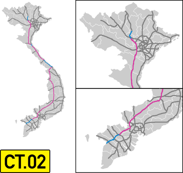
Vietnam CT 02 map
Any autopatrolled user can overwrite this file from the same source. Please ensure that overwrites comply with the guideline.
Summary
[edit]
| Description |
Tiếng Việt: Đường cao tốc Bắc – Nam (Tây Việt Nam)
English: North - South Expressway West (Vietnam)
Deutsch: Nord-Süd Schnellstraße West (Vietnam)
فارسی: نقشه آزادراه شماره 02 در ویتنام |
| Date | |
| Source | Own work |
| Author | Nima Farid |
Licensing
[edit]
I, the copyright holder of this work, hereby publish it under the following license:
This file is licensed under the Creative Commons Attribution-Share Alike 4.0 International license.
- You are free:
- to share – to copy, distribute and transmit the work
- to remix – to adapt the work
- Under the following conditions:
- attribution – You must give appropriate credit, provide a link to the license, and indicate if changes were made. You may do so in any reasonable manner, but not in any way that suggests the licensor endorses you or your use.
- share alike – If you remix, transform, or build upon the material, you must distribute your contributions under the same or compatible license as the original.
File history
Click on a date/time to view the file as it appeared at that time.
| Date/Time | Thumbnail | Dimensions | User | Comment | |
|---|---|---|---|---|---|
| current | 15:01, 30 June 2024 | | 936 × 886 (96 KB) | HikariTenshi (talk | contribs) | National Highway 46 - Bai Vot (remaining 19km of Dien Chau - Bai Vot) extension update |
| 16:54, 12 February 2024 |  | 936 × 886 (97 KB) | Liquidrekto (talk | contribs) | Tuyen Quang - Phu Tho extension | |
| 10:05, 11 January 2023 |  | 936 × 886 (95 KB) | HikariTenshi (talk | contribs) | supplement the missing route | |
| 06:29, 11 January 2023 |  | 936 × 886 (88 KB) | HikariTenshi (talk | contribs) | Update 2021 plane map | |
| 05:06, 13 March 2021 |  | 937 × 886 (65 KB) | BasilLeaf (talk | contribs) | Update, opening of Lộ Tẻ - Rạch Sỏi section | |
| 16:18, 14 May 2020 |  | 937 × 886 (61 KB) | BasilLeaf (talk | contribs) | Uploaded own work with UploadWizard |
You cannot overwrite this file.
File usage on Commons
The following 6 pages use this file:
- User:Chumwa/OgreBot/Transport Maps/2020 May 11-20
- User:Chumwa/OgreBot/Transport Maps/2021 March 11-20
- User:Chumwa/OgreBot/Transport Maps/2023 January 11-20
- User:Chumwa/OgreBot/Transport Maps/2024 February 10-19
- User:Chumwa/OgreBot/Transport Maps/2024 June 21-30
- User:Chumwa/OgreBot/Travel and communication maps/2024 June 21-30
File usage on other wikis
The following other wikis use this file:
- Usage on en.wikipedia.org
- Usage on fr.wikipedia.org
- Usage on vi.wikipedia.org
- Usage on zh.wikipedia.org