File:Versailler Vertrag.svg
Jump to navigation
Jump to search

Size of this PNG preview of this SVG file: 800 × 566 pixels. Other resolutions: 320 × 226 pixels | 640 × 453 pixels | 1,024 × 724 pixels | 1,280 × 905 pixels | 2,560 × 1,810 pixels | 1,052 × 744 pixels.
Original file (SVG file, nominally 1,052 × 744 pixels, file size: 1.74 MB)
Captions
Captions
Add a one-line explanation of what this file represents
Summary
[edit]| Description |
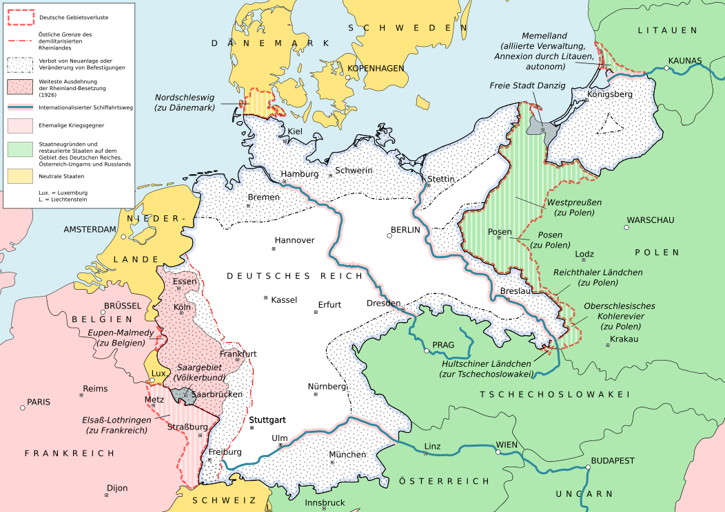
English: Results of the Versailles Treaty
Deutsch: Ergebnisse des Versailler Vertrags |
| Date | |
| Source | Own work based on: dtv-Atlas zur Weltgeschichte, Illustrierte Deutsche Geschichte, Leisering Historischer Weltatlas, Blank map of Europe 1914.svg, Blank map of Europe 1929-1938.svg |
| Author |
 |
| SVG development |

Licensing
[edit]
I, the copyright holder of this work, hereby publish it under the following license:
This file is licensed under the Creative Commons Attribution-Share Alike 3.0 Unported license.
- You are free:
- to share – to copy, distribute and transmit the work
- to remix – to adapt the work
- Under the following conditions:
- attribution – You must give appropriate credit, provide a link to the license, and indicate if changes were made. You may do so in any reasonable manner, but not in any way that suggests the licensor endorses you or your use.
- share alike – If you remix, transform, or build upon the material, you must distribute your contributions under the same or compatible license as the original.
File history
Click on a date/time to view the file as it appeared at that time.
| Date/Time | Thumbnail | Dimensions | User | Comment | |
|---|---|---|---|---|---|
| current | 16:50, 13 June 2021 | | 1,052 × 744 (1.74 MB) | Eisenberg (talk | contribs) | The Danube was only internationalized from Ulm onwards. See Article 331 of the Treaty of Versailles: " |
| 23:03, 12 November 2012 |  | 1,052 × 744 (1.75 MB) | Snipem (talk | contribs) | Fixed error | |
| 23:00, 12 November 2012 |  | 1,052 × 744 (1.75 MB) | Snipem (talk | contribs) | Added rivers | |
| 19:05, 12 November 2012 |  | 1,052 × 744 (1.73 MB) | Snipem (talk | contribs) | Corrected | |
| 17:23, 12 November 2012 |  | 1,052 × 744 (1.73 MB) | Snipem (talk | contribs) | {{Information |Description ={{en|1=Versailles treaty}} |Source =Self made |Author =MK |Date = |Permission = |other_versions = }} |
You cannot overwrite this file.
File usage on Commons
The following page uses this file:
File usage on other wikis
The following other wikis use this file:
- Usage on af.wikipedia.org
- Usage on de.wikipedia.org
- Usage on fr.wikipedia.org
- Usage on no.wikipedia.org
- Usage on rue.wikipedia.org
- Usage on sv.wikipedia.org