File:Versailler Vertrag.png
Jump to navigation
Jump to search

Size of this preview: 800 × 566 pixels. Other resolutions: 320 × 226 pixels | 640 × 452 pixels | 1,024 × 724 pixels | 1,280 × 905 pixels | 2,000 × 1,414 pixels.
Original file (2,000 × 1,414 pixels, file size: 587 KB, MIME type: image/png)
Captions
Captions
Add a one-line explanation of what this file represents
Summary
[edit]| Description |
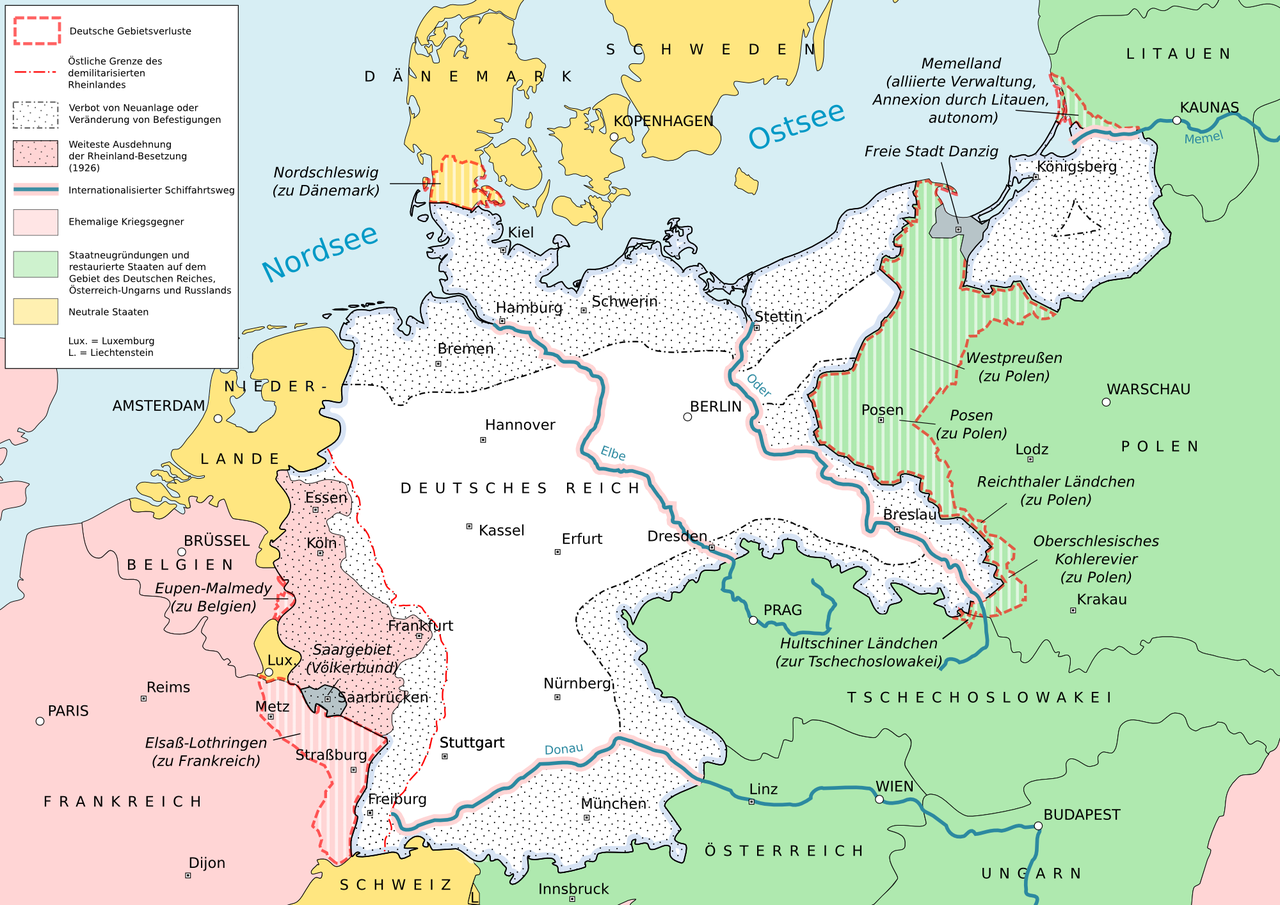
English: Results of the Versailles Treaty
Español: Resultados del Tratado de Versalles
Deutsch: Ergebnisse des Versailler Vertrags |
|||
| Date | ||||
| Source | Own work, Based upon dtv-Atlas zur Weltgeschichte, Illustrierte Deutsche Geschichte, Leisering Historischer Weltatlas, Blank_map_of_Europe_1914.svg, Blank_map_of_Europe_1929-1938.svg | |||
| Author | Matthias Küch | |||
| Other versions |
|


Licensing
[edit]
I, the copyright holder of this work, hereby publish it under the following license:
This file is licensed under the Creative Commons Attribution-Share Alike 3.0 Unported license.
- You are free:
- to share – to copy, distribute and transmit the work
- to remix – to adapt the work
- Under the following conditions:
- attribution – You must give appropriate credit, provide a link to the license, and indicate if changes were made. You may do so in any reasonable manner, but not in any way that suggests the licensor endorses you or your use.
- share alike – If you remix, transform, or build upon the material, you must distribute your contributions under the same or compatible license as the original.
File history
Click on a date/time to view the file as it appeared at that time.
| Date/Time | Thumbnail | Dimensions | User | Comment | |
|---|---|---|---|---|---|
| current | 19:02, 24 March 2014 | | 2,000 × 1,414 (587 KB) | NordNordWest (talk | contribs) | see disc |
| 18:59, 24 March 2014 |  | 2,000 × 1,414 (587 KB) | NordNordWest (talk | contribs) | whole Netherlands in yellow, no Afsluitdijk, no Flevoland | |
| 00:54, 24 March 2014 |  | 2,000 × 1,414 (587 KB) | Kopiersperre (talk | contribs) | optipng | |
| 23:03, 12 November 2012 |  | 2,000 × 1,414 (862 KB) | Snipem (talk | contribs) | Fixed error | |
| 23:00, 12 November 2012 |  | 2,000 × 1,414 (863 KB) | Snipem (talk | contribs) | Added rivers | |
| 19:06, 12 November 2012 |  | 2,000 × 1,414 (801 KB) | Snipem (talk | contribs) | Corrected Colours | |
| 17:03, 5 August 2012 |  | 1,497 × 1,058 (544 KB) | Snipem (talk | contribs) | Included change suggestions from german Kartenwerkstatt | |
| 11:00, 5 August 2012 |  | 1,497 × 1,058 (529 KB) | Snipem (talk | contribs) |
You cannot overwrite this file.
File usage on Commons
The following 2 pages use this file:
File usage on other wikis
The following other wikis use this file:
- Usage on am.wikipedia.org
- Usage on ar.wikipedia.org
- Usage on da.wikipedia.org
- Usage on de.wikipedia.org
- Usage on fi.wikipedia.org
- Usage on gn.wikipedia.org
- Usage on hu.wikipedia.org
- Usage on lv.wikipedia.org
- Usage on no.wikipedia.org
- Usage on sh.wikipedia.org