File:Verlauf des Verbots (Parkverbot), StVO 1956.jpg

Original file (1,597 × 1,181 pixels, file size: 1.53 MB, MIME type: image/jpeg)
Captions
Captions
Summary
[edit]| Description |
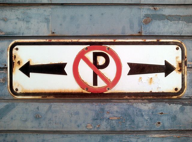
Deutsch: Zusatztafel „Verlauf des Verbots" mit Bild 23 „Parkverbot“. Ein auch im Jahr 2017 noch im Einsatz befindliches Schild. Die erste Version dieses Schildes wurde für die Straßenverkehrs-Ordnung (StVO) von 1937 eingeführt, die am 1. Januar 1938 rechtsgültig wurde. Das damals rechteckige Schild ohne schwarze Umrandung war 150 x 500 mm groß. Das hier gezeigte Schild gehört – wie die abgerundeten Ecken und der schwarze Rand zeigen – zur westdeutschen StVO-Novelle von 1956 und war bis zum 1. März 1971, als die erste westdeutsche Nachkriegs-StVO von 1970 in Kraft trat, ein verbindlich gültiges Verkehrszeichen. Mit der StVO von 1970 wurde das Schild aus dem Verkehrszeichenkatalog gestrichen. Die Bemaßungen des hier gezeigten plastisch aus Blech gestanzten Schildes, das ursprünglich im Siebdruckverfahren bedruckt war und spätere in den weißen und schwarzen Zonen Übermalungen erhielt, habe ich abgenommen. Sie sind folgende:
Das Schild hat acht mit der Stanzung bereits eingetiefte Bohrlöcher für verschiedene Anwendungszwecke. Das hier verwendete Bild 23 entspricht nicht den detaillierten Vorgaben, die 1956 erlassen worden sind. Schilder dieser Art wurde nicht nur aus Blech gestanzt, sondern auch auf Mauern gemalt. So habe ich 2016 an der Burgsteige, der Auffahrt zum Schloß Hohentübingen, eine solche aufgemalte Version dokumentieren können. Im August 2022 wurde das oben photographierte Schild entfernt, da das Gebäude, an dem es befestigt war, kernsaniert wurde. |
| Date | |
| Source | Own work |
| Author | Mediatus |
| Camera location | | View this and other nearby images on: OpenStreetMap |
|---|
| Camera Model | Lenovo Lifetab P831X.2 |
|---|---|
| Shutter speed | 1/160 Sek |
| Film speed (ISO) | 64 |
| Flash | no |
|
|
Do not upload new revisions over this file version without my explicit consent. Instead, use the possibility to upload a new version under a new name and tag it as a derivative or extract of this file. Mediatus |

,_StVO_1956.jpg&action=edit§ion=1)
,_StVO_1956.jpg¶ms=047.762319_N_0011.566472_E_globe:Earth_type:camera__&language=en)
Licensing
[edit],_StVO_1956.jpg&action=edit§ion=2)
| This file is licensed under the Creative Commons Attribution-Share Alike 3.0 Unported license. | ||
| Attribution: Mediatus (H.J.)/Wikimedia Commons/CC-BY-SA-3.0 & GFDL | ||
| ||
| This licensing tag was added to this file as part of the GFDL licensing update. |

|
Permission is granted to copy, distribute and/or modify this document under the terms of the GNU Free Documentation License, Version 1.2 or any later version published by the Free Software Foundation; with no Invariant Sections, no Front-Cover Texts, and no Back-Cover Texts. A copy of the license is included in the section entitled GNU Free Documentation License. |
File history
Click on a date/time to view the file as it appeared at that time.
| Date/Time | Thumbnail | Dimensions | User | Comment | |
|---|---|---|---|---|---|
| current | 16:49, 16 May 2017 | | 1,597 × 1,181 (1.53 MB) | Mediatus (talk | contribs) | {{Information |Description ={{de|1=Verlauf_des_Verbots_(Parkverbot),_StVO_1956.jpg}} |Source ={{own}} |Author =Mediatus |Date = |Permission = |other_versions = }} |
You cannot overwrite this file.
File usage on Commons
The following page uses this file:
,_StVO_1956.svg)
File usage on other wikis
The following other wikis use this file:
- Usage on de.wikipedia.org
,_StVO_1956.jpg&oldid=897349152)