File:Venezuela Yaracuy location map.svg

Original file (SVG file, nominally 512 × 448 pixels, file size: 1.8 MB)
Captions
Captions
Summary
![]() This SVG map is part of a locator map series applying the widespread location map scheme. Please see root category to browse for more.
This SVG map is part of a locator map series applying the widespread location map scheme. Please see root category to browse for more.
.svg)
.svg)
.svg)
.svg)
.svg)
.svg)
.svg)
Locator maps design recommendations ▼ | |
|---|---|
Principles
Design Guidelines are based on ▸location map design of the German map shop (in German). It's preferable to derive new locator maps from existing location maps. Please keep both size and ratio in this case. Thus the new locator maps may still be applied as location map (▸Guide). Marker color is supposed to be darkred. Waterbodies may be transparent, to show other objects better. Please be aware that this guide is only a recommendation. It’s not an inevitable law!
Highlight small areas
“Remote” areas and mini maps
Mini maps show where the depicted area actually is situated. Check out ▸Vorlage:Positionskarte+ (in German) and ▸Modèle:Carte en coin (in French) of how to insert a mini map in virtually every map.
Disputed areas
Greyed special objects
Backgrounds
|

-en.svg)

.svg)
.svg)
.svg)

_(US48).svg)
_(small_islands_magnified)_(-mini_map_-rivers).svg)
.svg)
_(extra_close)_(US48).svg)
.svg)
_(zoom).svg)

.svg)


_(UNMIK).svg)
.svg)
_(disputed_hatched).svg)
_(claimed_and_disputed_hatched).svg)
.svg)
.svg)
_(%2Ball_claims_hatched).svg)

.svg)
_(shade).svg)
_(shade)_(special_marker).svg)
_(-mini_map).svg)
_(-mini_map).svg)
_(-mini_map).svg)


.svg)

.svg)
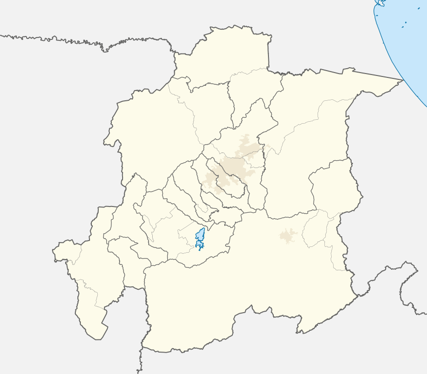
Map legend
- FDFBEA → Marked territory
- F2F2F2 → Other state/provinces of Venezuela
- 656564 → Lines/boundaries
- C7E7FB → Waterbodies
- 1278AB → Waterbodies border
- C6AF8B → Urban areas (25% transparency)
Geographic limits of the map (EPSG:4326)
- N: 10.8050
- S: 9.7751
- W: 69.3702
- E: 68.1746
Licensing
| Description |
English: Locator map of Yaracuy, Venezuela |
|||||||||
| SVG development | This map was created with Adobe Illustrator. |
|||||||||
| Date | ||||||||||
| Source | OpenStreetMap data, extracted via QGIS software. | |||||||||
| Creator |
OpenStreetMap contributors |
|||||||||
| Permission (Reusing this file) |
OpenStreetMap data is available under the Open Database License (details). Standard style map tiles are licensed as ODbL Produced Works.
|
|||||||||
| Geotemporal data | ||||||||||
| Bounding box |
|
|||||||||
File history
Click on a date/time to view the file as it appeared at that time.
| Date/Time | Thumbnail | Dimensions | User | Comment | |
|---|---|---|---|---|---|
| current | 19:56, 27 July 2023 | | 512 × 448 (1.8 MB) | Wguayana (talk | contribs) | Cambio de color |
| 19:49, 27 July 2023 |  | 512 × 448 (1.8 MB) | Wguayana (talk | contribs) | OpenStreetMap 2023 data | |
| 22:58, 12 May 2010 |  | 685 × 638 (202 KB) | Addicted04 (talk | contribs) | rivers | |
| 00:29, 11 May 2010 |  | 685 × 638 (40 KB) | Addicted04 (talk | contribs) | {{Information |Description={{en|1=Geographic limits of the map:<br/>* West : 69.3° W<br/>* East : 68.1° W<br/>* North : 10.9° N<br/>* South : 9.8° N}} {{es|1=Límites geográficos del mapa:<br/>* Oeste : 69.3° O<br/>* Este : 68.1° O<br/>* Norte : 10 |
You cannot overwrite this file.
File usage on Commons
There are no pages that use this file.
File usage on other wikis
The following other wikis use this file:
- Usage on de.wikipedia.org
- Usage on eo.wikipedia.org
- Usage on es.wikipedia.org
- Nirgua
- San Felipe (Venezuela)
- Yaritagua
- Chivacoa
- Guama
- Farriar
- Aroa
- Sabana de Parra
- Urachiche
- San Pablo (Yaracuy)
- Parque de la Exótica Flora Tropical
- Parque de Recreación Embalse Cumaripa
- Wikiproyecto:Ilustración/Taller de Cartografía/Realizaciones/América del Sur
- Salom (Yaracuy)
- Wikiproyecto:Ilustración/Taller gráfico/Peticiones/Archivo 11
- Plantilla:Mapa de localización de Yaracuy
- Parroquia Salom
- Boraure
- Yumare
- Independencia (Yaracuy)
- Usage on os.wikipedia.org
- Usage on ru.wikipedia.org