File:VedutadelMoncenisio.JPG
Jump to navigation
Jump to search

Size of this preview: 800 × 176 pixels. Other resolutions: 320 × 70 pixels | 640 × 141 pixels | 1,024 × 225 pixels | 1,280 × 281 pixels | 4,912 × 1,080 pixels.
Original file (4,912 × 1,080 pixels, file size: 1.94 MB, MIME type: image/jpeg)
Captions
Captions
Add a one-line explanation of what this file represents
Summary
[edit]
| Description |
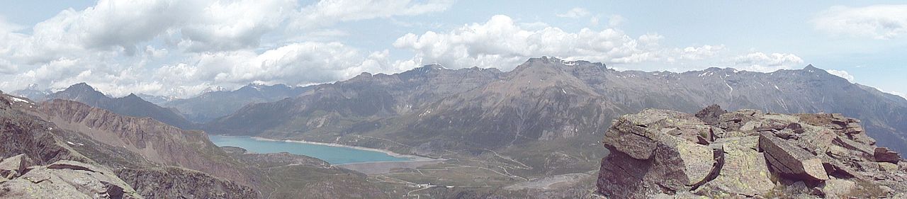
Italiano: L’altipiano del Moncenisio con il suo lago visto dalla cresta del Monte Giusalet (3312m) sopra il Rifugio Piero Vacca (2675) nell’estate del 2015. Sono visibili (da sinistra verso destra) la Punta Clairy (3162m), il Passo de la Beccia (2717m) e la Cima du Laro (2881m) parte delle Alpi Cozie, il Colle del Moncenisio (2081m), che divide le Alpi Cozie dalle Graie (dietro questo, sotto le nuvole, il Massiccio della Vanoise che sovrasta la Moriana), Ouillon des Arcellins (2665m), Sommet de la Nunda(3025m), Col du Lou (3024m), Signal du Grand Mont Cenis(3377m), Punta Roncia(3612m), Pointe du Vieux (3464m), Pointe de la Haie (3452m), Punta Lamet(3504m), Roche Michel (3429), I Tre Denti(3281-3285m), Punta Marmottere(3387m), Passo della Novalesa, Rocciamelone (3537m) parte delle Alpi Graie. Sotto la Punta Lamet si scorge il luogo dove sorgeva la Batteria Paradiso e dove sono ancora presenti i ruderi della Batteria La Court. Si nota anche la Strada statale 25 del Moncenisio |
| Date | |
| Source | Own work |
| Author | Marco Siano |
Licensing
[edit]
I, the copyright holder of this work, hereby publish it under the following licenses:
This file is licensed under the Creative Commons Attribution-Share Alike Attribution-Share Alike 4.0 International, 3.0 Unported, 2.5 Generic, 2.0 Generic and 1.0 Generic license.
- You are free:
- to share – to copy, distribute and transmit the work
- to remix – to adapt the work
- Under the following conditions:
- attribution – You must give appropriate credit, provide a link to the license, and indicate if changes were made. You may do so in any reasonable manner, but not in any way that suggests the licensor endorses you or your use.
- share alike – If you remix, transform, or build upon the material, you must distribute your contributions under the same or compatible license as the original.

|
Permission is granted to copy, distribute and/or modify this document under the terms of the GNU Free Documentation License, Version 1.2 or any later version published by the Free Software Foundation; with no Invariant Sections, no Front-Cover Texts, and no Back-Cover Texts. A copy of the license is included in the section entitled GNU Free Documentation License. |
You may select the license of your choice.
File history
Click on a date/time to view the file as it appeared at that time.
| Date/Time | Thumbnail | Dimensions | User | Comment | |
|---|---|---|---|---|---|
| current | 21:13, 26 December 2016 | 4,912 × 1,080 (1.94 MB) | Marco Siano (talk | contribs) | {{Information |Description ={{it|1=L’altipiano del Moncenisio con il suo lago visto dalla cresta del Monte Giusalet (3312m) sopra il Rifugio Piero Vacca (2675) nell’estate del 2015. Sono visibili (da sinis... |
You cannot overwrite this file.
File usage on Commons
There are no pages that use this file.
File usage on other wikis
The following other wikis use this file:
- Usage on it.wikipedia.org