File:VIIRS view of the 2021 Suez Canal obstruction.jpg
Jump to navigation
Jump to search
No higher resolution available.
VIIRS_view_of_the_2021_Suez_Canal_obstruction.jpg (720 × 480 pixels, file size: 80 KB, MIME type: image/jpeg)
Captions
Captions
Add a one-line explanation of what this file represents
Summary
[edit]
| Description |
Español: Comparación del tráfico en el Canal de Suez antes y después del bloqueo causado por el Ever Given visto por el instrumento VIIRS del satélite Suomi National Polar-orbiting Partnership.
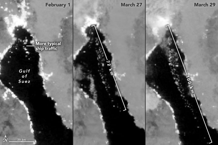
English: The series of nighttime images above, all acquired with the Visible Infrared Imaging Radiometer Suite (VIIRS) on the Suomi NPP satellite, offers another view of ships waiting in the Gulf of Suez. The VIIRS “day-night band” detects light in a range of wavelengths from green to near-infrared and uses filtering techniques to enhance dim signals such as moonlight, gas flares, and the lights on ships. The left image shows typical ship traffic in the Gulf of Suez on February 1, 2021. By March 27, the line of waiting ships stretched 72 kilometers (45 miles). Two days later, ships waited as far as 100 kilometers (60 miles) from the canal entry. According to Leth Agencies, 184 vessels were still waiting to get through on March 30. |
| Date | |
| Source | https://earthobservatory.nasa.gov/images/148114/traffic-jam-on-the-suez-canal?utm_source=TWITTER&utm_medium=NASAOcean&utm_campaign=NASASocial&linkId=114935299 |
| Author | NASA Earth Observatory images by Lauren Dauphin and Joshua Stevens, using Landsat data from the U.S. Geological Survey and VIIRS day-night band data from the Suomi National Polar-orbiting Partnership. |
Licensing
[edit]
| This file is in the public domain in the United States because it was solely created by NASA. NASA copyright policy states that "NASA material is not protected by copyright unless noted". (See Template:PD-USGov, NASA copyright policy page or JPL Image Use Policy.) | ||
 |
Warnings:
|
File history
Click on a date/time to view the file as it appeared at that time.
| Date/Time | Thumbnail | Dimensions | User | Comment | |
|---|---|---|---|---|---|
| current | 18:15, 30 March 2021 | | 720 × 480 (80 KB) | BugWarp (talk | contribs) | Uploaded a work by NASA Earth Observatory images by Lauren Dauphin and Joshua Stevens, using Landsat data from the U.S. Geological Survey and VIIRS day-night band data from the Suomi National Polar-orbiting Partnership. from https://earthobservatory.nasa.gov/images/148114/traffic-jam-on-the-suez-canal?utm_source=TWITTER&utm_medium=NASAOcean&utm_campaign=NASASocial&linkId=114935299 with UploadWizard |
You cannot overwrite this file.
File usage on Commons
There are no pages that use this file.
File usage on other wikis
The following other wikis use this file:
- Usage on nl.wikipedia.org