File:VIIRS Data Captures Raging Wildfires in California (NESDIS 2017-10-10).png
Jump to navigation
Jump to search

Size of this preview: 800 × 450 pixels. Other resolutions: 320 × 180 pixels | 640 × 360 pixels | 1,024 × 576 pixels | 1,280 × 720 pixels | 1,920 × 1,080 pixels.
Original file (1,920 × 1,080 pixels, file size: 1.15 MB, MIME type: image/png)
Captions
Captions
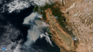
Data from the VIIRS instrument aboard NOAA/NASA Suomi NPP satellite from October 9, 2017 shows the extent of the fires burning in California.
Summary
[edit].png&action=edit§ion=1)
| Description |
English: Data from the VIIRS instrument aboard NOAA/NASA Suomi NPP satellite from October 9, 2017 shows the extent of the fires burning in California. This image combines the satellite's true color imagery along with thermal imagery (in red) that indicates the hot spots associated with the active fires. According to information shared at 1:00PM EDT Oct. 10th from the Department of Forestry and Fire Protection, 17 large wildfires that started in the past 36 hours continue to burn across California and have burned over 115,000 acres. |
| Date | 10 October 2017 (upload date) |
| Source | VIIRS Data Captures Raging Wildfires in California |
| Author | NOAA |
Licensing
[edit].png&action=edit§ion=2)
This image is in the public domain because it contains materials that originally came from the U.S. National Oceanic and Atmospheric Administration, taken or made as part of an employee's official duties.
|
File history
Click on a date/time to view the file as it appeared at that time.
| Date/Time | Thumbnail | Dimensions | User | Comment | |
|---|---|---|---|---|---|
| current | 15:58, 2 June 2024 | | 1,920 × 1,080 (1.15 MB) | OptimusPrimeBot (talk | contribs) | #Spacemedia - Upload of https://nesdis-prod.s3.amazonaws.com/migrated/2117v1_20171010-CAFires.png via Commons:Spacemedia |
You cannot overwrite this file.
File usage on Commons
There are no pages that use this file.
.png&oldid=880929338)