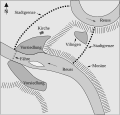
File:Urkirche-Bremgarten.svg
From Wikimedia Commons, the free media repository
Jump to navigation
Jump to search

Size of this PNG preview of this SVG file: 487 × 465 pixels. Other resolutions: 251 × 240 pixels | 503 × 480 pixels | 804 × 768 pixels | 1,072 × 1,024 pixels | 2,145 × 2,048 pixels.
Original file (SVG file, nominally 487 × 465 pixels, file size: 44 KB)
File information
Structured data
Captions
Captions
Add a one-line explanation of what this file represents
Summary
[edit]| DescriptionUrkirche-Bremgarten.svg | Map of eleventh century. Settlements «Bremgarten» and «Vilingen». Source: Cornel Doswald, Die Ausgrabungen in der Stadtkirche Bremgarten und die frühe Stadtgeschichte, in: Bremgarter Neujahrsblätter 1986 |
| Date | |
| Source | Own work |
| Author | Micha L. Rieser |
Licensing
[edit]
|
The copyright holder of this file, Micha L. Rieser, allows anyone to use it for any purpose, provided that the copyright holder is properly attributed. Redistribution, derivative work, commercial use, and all other use is permitted. |
Attribution:
Micha L. Rieser Attribution |
File history
Click on a date/time to view the file as it appeared at that time.
| Date/Time | Thumbnail | Dimensions | User | Comment | |
|---|---|---|---|---|---|
| current | 21:08, 4 May 2008 |  | 487 × 465 (44 KB) | Micha (talk | contribs) | {{Information |Description=Karte des 11. Jahrhunderts. Vorsiedlung Bremgarten AG. Schweiz. |Source=self-made |Date=May 4, 2008 |Author= Micha L. Rieser |Permission= |other_versions= }} |
| 17:48, 4 May 2008 |  | 487 × 465 (44 KB) | Micha (talk | contribs) | {{Information |Description=Karte des 11. Jahrhunderts. Vorsiedlung Bremgarten AG. Schweiz. |Source=self-made |Date=May 4, 2008 |Author= Micha L. Rieser |Permission= |other_versions= }} | |
| 17:17, 4 May 2008 |  | 487 × 465 (44 KB) | Micha (talk | contribs) | {{Information |Description=Karte des 11. Jahrhunderts. Vorsiedlung Bremgarten AG. Schweiz. |Source=self-made |Date=May 4, 2008 |Author= Micha L. Rieser |Permission= |other_versions= }} |
You cannot overwrite this file.
File usage on Commons
There are no pages that use this file.
File usage on other wikis
The following other wikis use this file:
- Usage on de.wikipedia.org
Hidden categories: