File:UppudaluwaWindFarm-SriLanka-02.JPG
Original file (4,000 × 2,248 pixels, file size: 1.46 MB, MIME type: image/jpeg)
Captions
Summary
[edit]DescriptionUppudaluwaWindFarm-SriLanka-02.JPG |
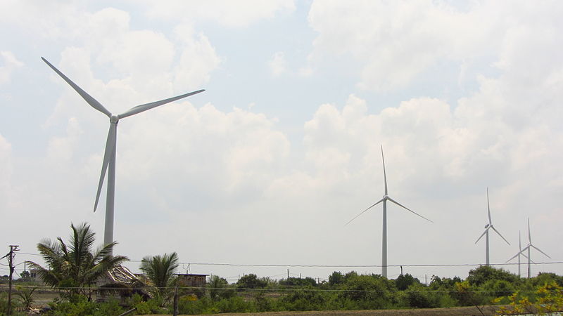
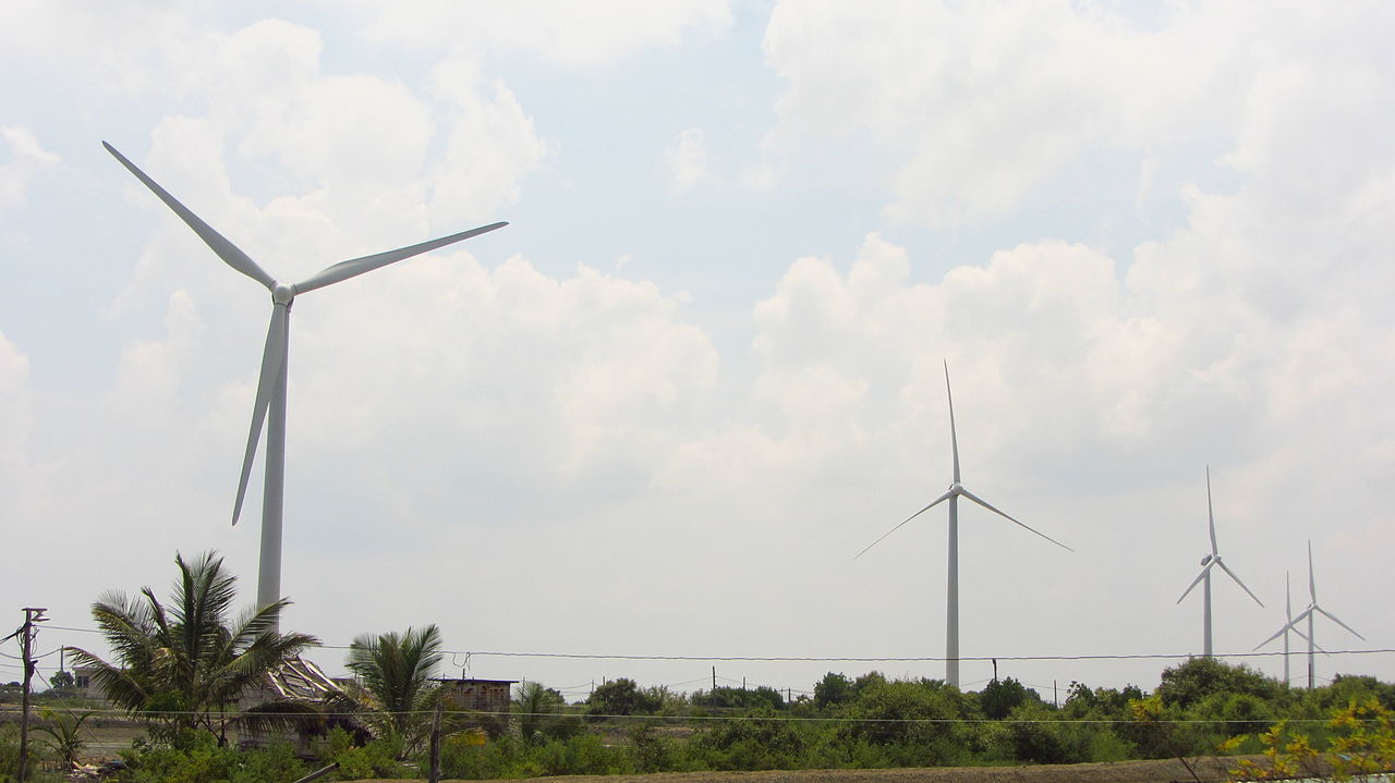
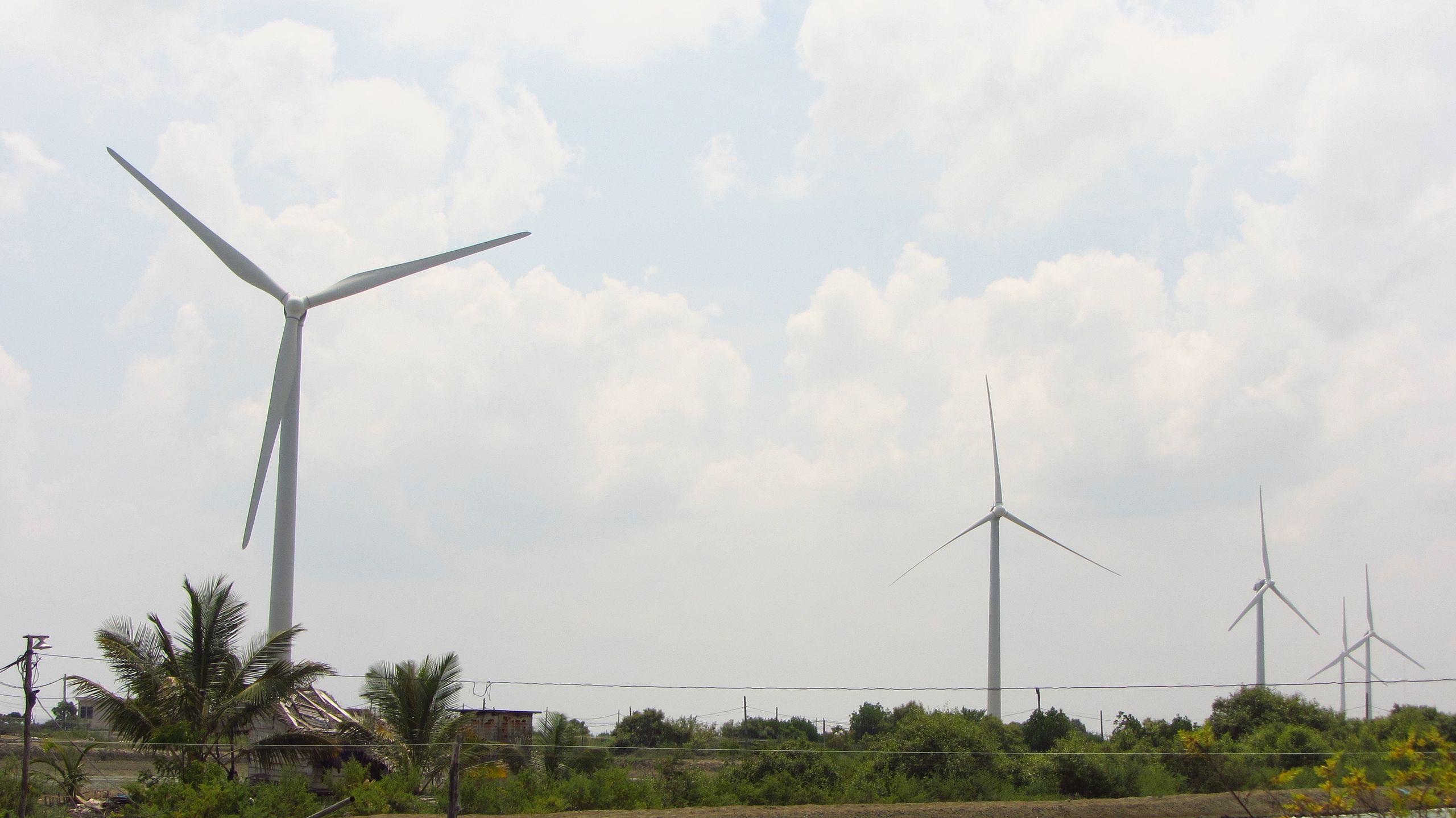
English: Five of the seven Leitner Shriram LTW-77-1.5 wind turbines of the Uppudaluwa Wind Farm in the Puttalam District of Sri Lanka. |
Date | |
Source | Own work |
Author | Rehman Abubakr |
Camera location | 7° 58′ 39.53″ N, 79° 46′ 41.61″ E | View this and other nearby images on: OpenStreetMap | 7.977646; 79.778224 |
---|
Licensing
[edit]IMPORTANT
If you use this file outside the Wikimedia Projects, you are violating copyright unless you:
I, the copyright holder of this work, hereby publish it under the following license: This file is licensed under the Creative Commons Attribution-Share Alike 4.0 International license. Attribution: Rehman Abubakr
|
File history
Click on a date/time to view the file as it appeared at that time.
Date/Time | Thumbnail | Dimensions | User | Comment | |
---|---|---|---|---|---|
current | 01:58, 1 May 2014 | 4,000 × 2,248 (1.46 MB) | Rehman (talk | contribs) | User created page with UploadWizard |
You cannot overwrite this file.
File usage on Commons
The following page uses this file:
File usage on other wikis
The following other wikis use this file:
- Usage on en.wikipedia.org
- Usage on www.wikidata.org
Metadata
This file contains additional information such as Exif metadata which may have been added by the digital camera, scanner, or software program used to create or digitize it. If the file has been modified from its original state, some details such as the timestamp may not fully reflect those of the original file. The timestamp is only as accurate as the clock in the camera, and it may be completely wrong.
Camera manufacturer | Canon |
---|---|
Camera model | Canon PowerShot SX230 HS |
Author | Rehman Abubakr |
Exposure time | 1/1,600 sec (0.000625) |
F-number | f/4 |
ISO speed rating | 160 |
Date and time of data generation | 10:49, 27 April 2014 |
Lens focal length | 9.555 mm |
Latitude | 7° 58′ 39.53″ N |
Longitude | 79° 46′ 41.61″ E |
Altitude | 9.82 meters above sea level |
Orientation | Normal |
Horizontal resolution | 180 dpi |
Vertical resolution | 180 dpi |
File change date and time | 10:49, 27 April 2014 |
Y and C positioning | Co-sited |
Exif version | 2.3 |
Date and time of digitizing | 10:49, 27 April 2014 |
Meaning of each component |
|
Image compression mode | 3 |
APEX shutter speed | 10.65625 |
APEX aperture | 4 |
APEX exposure bias | 0 |
Maximum land aperture | 4 APEX (f/4) |
Metering mode | Pattern |
Flash | Flash did not fire, compulsory flash suppression |
Supported Flashpix version | 1 |
Color space | sRGB |
Focal plane X resolution | 16,393.442622951 |
Focal plane Y resolution | 16,393.442622951 |
Focal plane resolution unit | inches |
Sensing method | One-chip color area sensor |
File source | Digital still camera |
Custom image processing | Normal process |
Exposure mode | Auto exposure |
White balance | Manual white balance |
Digital zoom ratio | 1 |
Scene capture type | Standard |
GPS time (atomic clock) | 05:19 |
Receiver status | Measurement in progress |
Geodetic survey data used | WGS-84 |
GPS date | 27 April 2014 |
GPS tag version | 2.3.0.0 |
Rating (out of 5) | 0 |