File:Upper kachura 2.jpg
Original file (3,992 × 2,242 pixels, file size: 8.03 MB, MIME type: image/jpeg)
Captions
Summary
[edit]DescriptionUpper kachura 2.jpg |
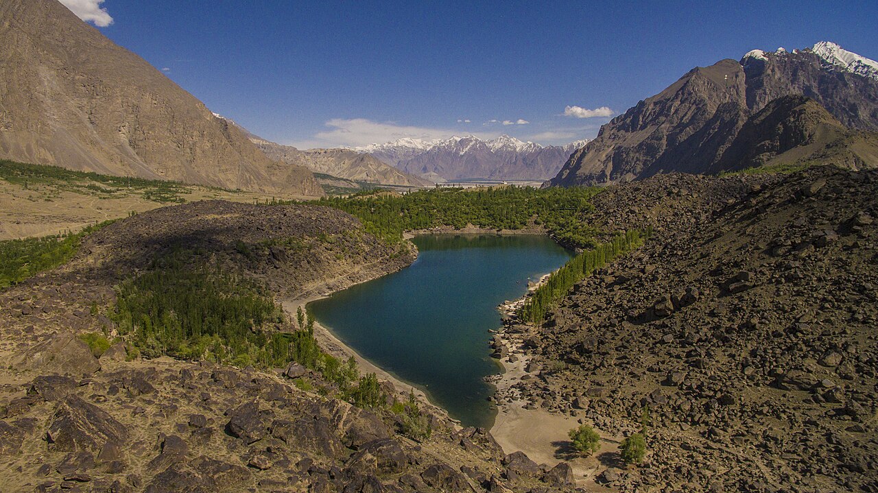
English: Upper Kachura Lake is in Skardu District and is bigger then Lower Kachura Lake which is also known as Shangrila Lake.
Upper Kachura Lake is natural whereas Shangrila Lake is 70% man-made. This picture is captured using drone, as it was the only easy way to get the whole lake in one picture, otherwise one have to hike up to the mountains which might take days only to have a clear view without any obstetrical like trees or boulders on the way. |
Date | |
Source | Own work |
Author | ADIL RIAZ |
Other versions |
|
Camera location | 35° 27′ 05.55″ N, 75° 26′ 26.11″ E | View this and other nearby images on: OpenStreetMap | 35.451542; 75.440587 |
---|
Licensing
[edit]- You are free:
- to share – to copy, distribute and transmit the work
- to remix – to adapt the work
- Under the following conditions:
- attribution – You must give appropriate credit, provide a link to the license, and indicate if changes were made. You may do so in any reasonable manner, but not in any way that suggests the licensor endorses you or your use.
- share alike – If you remix, transform, or build upon the material, you must distribute your contributions under the same or compatible license as the original.
This image was uploaded as part of Wiki Loves Earth 2017.
aragonés | العربية | asturianu | azərbaycanca | беларуская (тарашкевіца) | български | বাংলা | brezhoneg | català | čeština | Cymraeg | Deutsch | Ελληνικά | English | español | eesti | euskara | فارسی | français | galego | עברית | hrvatski | հայերեն | Bahasa Indonesia | italiano | 日本語 | ქართული | 한국어 | latviešu | македонски | മലയാളം | मराठी | Bahasa Melayu | norsk bokmål | नेपाली | Nederlands | norsk | polski | português | português do Brasil | русский | sicilianu | shqip | slovenščina | српски / srpski | svenska | ไทย | Türkçe | українська | اردو | 中文 | 中文(台灣) | +/− |
File history
Click on a date/time to view the file as it appeared at that time.
Date/Time | Thumbnail | Dimensions | User | Comment | |
---|---|---|---|---|---|
current | 03:55, 11 May 2017 | 3,992 × 2,242 (8.03 MB) | Aadilriazkhan (talk | contribs) | User created page with UploadWizard |
You cannot overwrite this file.
File usage on Commons
The following page uses this file:
Metadata
This file contains additional information such as Exif metadata which may have been added by the digital camera, scanner, or software program used to create or digitize it. If the file has been modified from its original state, some details such as the timestamp may not fully reflect those of the original file. The timestamp is only as accurate as the clock in the camera, and it may be completely wrong.
Camera manufacturer | DJI |
---|---|
Camera model | FC300X |
Exposure time | 1/5,000 sec (0.0002) |
F-number | f/2.8 |
ISO speed rating | 200 |
Date and time of data generation | 15:01, 8 May 2016 |
Lens focal length | 3.61 mm |
Latitude | 35° 27′ 5.55″ N |
Longitude | 75° 26′ 26.11″ E |
Altitude | 2,464.442 meters above sea level |
height | 2,242 |
width | 3,992 |
Horizontal resolution | 240 dpi |
Vertical resolution | 240 dpi |
Software used | Adobe Photoshop Camera Raw 7.0 (Windows) |
File change date and time | 11:32, 13 May 2016 |
Exposure Program | 8176 |
Exif version | 2.3 |
Date and time of digitizing | 15:01, 8 May 2016 |
APEX shutter speed | 12.287712 |
APEX aperture | 2.970854 |
APEX exposure bias | 0 |
Maximum land aperture | 2 APEX (f/2) |
Subject distance | 0 meters |
Metering mode | Center weighted average |
Light source | Daylight |
Flash | Flash did not fire, No flash function |
File source | Digital still camera |
Scene type | A directly photographed image |
Custom image processing | Normal process |
Exposure mode | Manual exposure |
White balance | Manual white balance |
Digital zoom ratio | 0 |
Focal length in 35 mm film | 20 mm |
Scene capture type | Standard |
Scene control | None |
Contrast | Normal |
Saturation | Normal |
Sharpness | Normal |
Subject distance range | Unknown |
GPS tag version | 0.0.3.2 |
Serial number of camera | 2014031100 |
Lens used | 20.7 mm |
Date metadata was last modified | 16:32, 13 May 2016 |
Unique ID of original document | 74B8A443283D498D67FE1E5A708609B6 |
IIM version | 4 |
Structured data
Items portrayed in this file
depicts
35°27'5.551"N, 75°26'26.113"E
8 May 2016
0.0002 second
2.8
3.61 millimetre
200
image/jpeg
- Files with coordinates missing SDC location of creation
- CC-BY-SA-4.0
- Self-published work
- Images from Wiki Loves Earth 2017
- Images from Wiki Loves Earth 2017 in Pakistan
- Images from Wiki Loves Earth missing SDC depicts
- Images from Wiki Loves Earth missing SDC location of creation
- Uploaded via Campaign:wle-pk
- Pakistan photographs taken on 2016-05-08