File:Unrest at Turrialba Volcano, Costa Rica.jpg
Jump to navigation
Jump to search

Size of this preview: 800 × 550 pixels. Other resolutions: 320 × 220 pixels | 640 × 440 pixels | 1,024 × 704 pixels | 1,280 × 880 pixels | 2,560 × 1,761 pixels | 3,219 × 2,214 pixels.
Original file (3,219 × 2,214 pixels, file size: 4.63 MB, MIME type: image/jpeg)
Captions
Captions
Add a one-line explanation of what this file represents
Summary
[edit]
| Description |
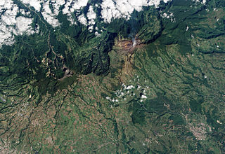
English: Turrialba Volcano, located in central Costa Rica, emits a translucent plume of volcanic gases in this natural-colour satellite image. The barren summit region of the 3,340-meter high Turrialba appears grey and brown, while the volcanic plume is a hazy blue. Fields and pastures are light green, in contrast to dark green forest that covers the high-elevation ridges. Since 2007, frequent acid rain showers caused by activity at the volcano killed or damaged much of the vegetation to the south-west of the summit, leaving the area brown and orange. |
| Date | |
| Source | NASA Earth Observatory |
| Author | Robert Simmon |
This image was acquired by the Advanced Land Imager (ALI) aboard NASA’s Earth Observing-1 (EO-1) satellite. ALI data provided by the NASA EO-1 team.
Licensing
[edit]
| This file is in the public domain in the United States because it was solely created by NASA. NASA copyright policy states that "NASA material is not protected by copyright unless noted". (See Template:PD-USGov, NASA copyright policy page or JPL Image Use Policy.) | ||
 |
Warnings:
|
| Annotations | This image is annotated: View the annotations at Commons |
File history
Click on a date/time to view the file as it appeared at that time.
| Date/Time | Thumbnail | Dimensions | User | Comment | |
|---|---|---|---|---|---|
| current | 14:53, 28 January 2010 | | 3,219 × 2,214 (4.63 MB) | Originalwana (talk | contribs) | {{Information |Description={{en|1=Turrialba Volcano, located in central Costa Rica, emits a translucent plume of volcanic gases in this natural-colour satellite image. The barren summit region of the 3,340-meter high Turrialba appears grey and brown, |
You cannot overwrite this file.
File usage on Commons
There are no pages that use this file.
File usage on other wikis
The following other wikis use this file:
- Usage on en.wikipedia.org
- Usage on es.wikipedia.org
- Usage on et.wikipedia.org
- Usage on it.wikipedia.org
- Usage on pl.wikipedia.org
- Usage on zh.wikipedia.org