File:Unnamed Road, Cape cross, Namibia - panoramio.jpg
Jump to navigation
Jump to search

Size of this preview: 800 × 600 pixels. Other resolutions: 320 × 240 pixels | 640 × 480 pixels | 1,024 × 768 pixels | 1,280 × 960 pixels | 1,600 × 1,200 pixels.
Original file (1,600 × 1,200 pixels, file size: 353 KB, MIME type: image/jpeg)
Captions
Captions
Add a one-line explanation of what this file represents
Summary
[edit]
| Description |
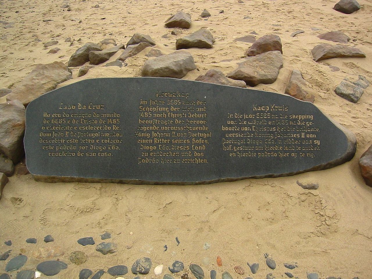
Afrikaans: Kaap Kruis: In die jaar 6685 na die skepping van die wêreld en 1485 na die geboorte van Christus het die briljante, versiende koning Johannes II van Portugal vir Diogo Cão, 'n ridder van sy hof, gestuur om hierdie land te ontdek en hierdie padrão hier op te rig.
Deutsch: Kreuzkap: Im Jahre 6685 nach der Schöpfung der Welt und 1485 nach Christi Geburt beauftragte der hervorragende, vorausschauende König Johann II. von Portugal einen Ritter seines Hofes, Diogo Cão, dieses Land zu endecken und das Padrão hier zu errichten.
English: Unnamed Road, Cape Cross, Namibia: In the year 6685 since the creation of the world and the year 1485 of our Lord, the excellent and enlightened King Dom João II of Portugal ordered Diogo Cão, a knight of his court, to discover this land and to erect a padrão here.
Português: Cabo da Cruz: Na era da criação do mundo de 6685 e de Christo de 1485 o excelente e esclarecido Rei Dom João II de Portugal mandou descobrir esta terra e colocar este padrão por Diogo Cão, cavaleiro de sua casa. |
||
| Date | Taken on 22 July 2009 | ||
| Source | https://web.archive.org/web/20161016133033/http://www.panoramio.com/photo/44287071 | ||
| Author | mroszewski | ||
| Permission (Reusing this file) |
This file is licensed under the Creative Commons Attribution-Share Alike 3.0 Unported license. Attribution: mroszewski
|
||
| Tags (from Panoramio photo page) | Cape cross |
| Camera location | | View this and other nearby images on: OpenStreetMap |
|---|
File history
Click on a date/time to view the file as it appeared at that time.
| Date/Time | Thumbnail | Dimensions | User | Comment | |
|---|---|---|---|---|---|
| current | 13:07, 19 November 2016 | | 1,600 × 1,200 (353 KB) | Panoramio upload bot (talk | contribs) | == {{int:filedesc}} == {{Information |description=Unnamed Road, Cape cross, Namibia |date={{Taken on|2009-07-22}} |source=http://www.panoramio.com/photo/44287071 |author=[http://www.panoramio.com/user/4982015?with_photo_id=44287071 mroszewski] |permiss... |
You cannot overwrite this file.
File usage on Commons
There are no pages that use this file.