File:Unica quarry wall 2007.jpg
Jump to navigation
Jump to search

Size of this preview: 800 × 532 pixels. Other resolutions: 320 × 213 pixels | 640 × 426 pixels | 1,024 × 681 pixels | 1,200 × 798 pixels.
Original file (1,200 × 798 pixels, file size: 977 KB, MIME type: image/jpeg)
Captions
Captions
Add a one-line explanation of what this file represents
Summary
[edit]
| Description |
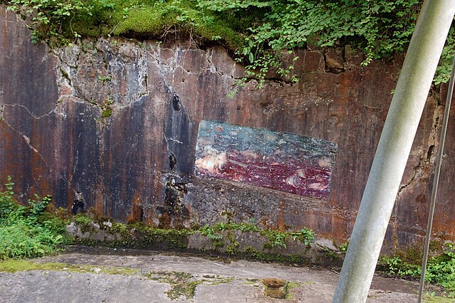
Deutsch: Abbaufront im auflässigen Unica-Bruch in Villmar, Hessen. Die Wand besteht aus einem angewitterten devonischen Riffkalk („Lahnmarmor“) des östlichen Rheinischen Schiefergebirges. Ein rechteckiger Bereich in der Wand ist frisch angeschliffen und zeigt den inneren Aufbau des Kalksteins. Bei den gräulichen „Flecken“ darin handelt es sich um Stromatoporen, kalkschwammähnliche Fossilien.
English: Quarry wall in the abandoned Unica limestone quarry in the town of Villmar, Hesse, Germany. The wall consists of weathered Devonian reefal limestone (“Lahnmarmor”, i.e. “River Lahn Marble”) of the eastern Rhenish Massif. A freshly polished rectangular area at the wall shows the internal structure of the limestone. The grayish “patches” therein represent stromatoporoids which are fossils similar to calcareous sponges. |
| Date | |
| Source | Own work |
| Author | Fritz Geller-Grimm |
| Permission (Reusing this file) |
I, the copyright holder of this work, hereby publish it under the following license: This file is licensed under the Creative Commons Attribution-Share Alike 3.0 Unported license.
|
| Camera location | | View this and other nearby images on: OpenStreetMap |
|---|
File history
Click on a date/time to view the file as it appeared at that time.
| Date/Time | Thumbnail | Dimensions | User | Comment | |
|---|---|---|---|---|---|
| current | 15:53, 31 December 2008 | | 1,200 × 798 (977 KB) | Dysmachus (talk | contribs) | {{Information| |Description= {{de|Lahnmarmor, Steinbruch Unica A, Villmar, Hessen, Deutschland}} |Source=Own work |Date=2007-07-07 |Author=Fritz Geller-Grimm |Permission={{self|cc-by-sa-3.0}} |other_versions=- }} Category:Villmar |
You cannot overwrite this file.
File usage on Commons
The following page uses this file:
- File:Villmar fg03.jpg (file redirect)
File usage on other wikis
The following other wikis use this file:
- Usage on de.wikipedia.org
- Usage on www.wikidata.org