File:Ungarn im Zweiten Weltkrieg.png
Jump to navigation
Jump to search

Size of this preview: 800 × 555 pixels. Other resolutions: 320 × 222 pixels | 640 × 444 pixels | 1,024 × 710 pixels | 1,184 × 821 pixels.
Original file (1,184 × 821 pixels, file size: 225 KB, MIME type: image/png)
Captions
Captions
Add a one-line explanation of what this file represents
Summary
[edit]| Description |
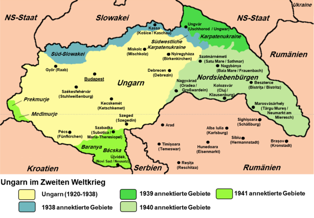
Deutsch: Karte der von Ungarn annektierten Gebiete 1938-1941.
English: Map of territories annexed by Hungary in 1938-1941. |
||
| Date | |||
| Source | Own work - derivative work; modified version of File:Hungary map.png whose authors were Mixx321 and User:PANONIAN, added German descriptions and Transsylvanien cities of Romania | ||
| Author | Dr-Victor-von-Doom | ||
| Permission (Reusing this file) |
I, the copyright holder of this work, hereby publish it under the following license:
|

References
[edit]
- The Times History of Europe, Times Books, London, 2002
- Richard Overy, The Times History of the 20th Century, Times Books, London, 2004.
- Peter Rokai - Zoltan Đere - Tibor Pal - Aleksandar Kasaš, Istorija Mađara, Beograd, 2002.
- http://terkepek.adatbank.transindex.ro/kepek/netre/224.gif
- http://www.hunmagyar.org/tor/terkep.jpg
- http://www.map.hu/galeria/orig/1426_hu_in_maps_fig_12_states_1648-2009.jpg
- http://magyar.files.wordpress.com/2006/07/11399032041.JPG?w=440&h=343
- http://crowland.uw.hu/images/csata/delvidek_02.jpg
- http://www.conflicts.rem33.com/images/Ungarn/hunhist_V_files/image004.jpg
File history
Click on a date/time to view the file as it appeared at that time.
| Date/Time | Thumbnail | Dimensions | User | Comment | |
|---|---|---|---|---|---|
| current | 07:32, 20 July 2020 | | 1,184 × 821 (225 KB) | Dr-Victor-von-Doom (talk | contribs) | Rahmen der Farb-Legende vereinheitlicht |
| 06:36, 20 July 2020 |  | 1,178 × 823 (224 KB) | Dr-Victor-von-Doom (talk | contribs) | {{Information |Description= {{de|1=Karte der von Ungarn annektierten Gebiete 1938-1941.}} {{en|1=Map of territories annexed by Hungary in 1938-1941.}} |Source={{own}} - derivative work; modified version of this map (added German descriptions and Transsylvanien cities of Romania) whose authors were Mixx321, User:PANONIAN: File:Hungary map.png. |Author=Dr-Victor-von-Doom |Date=2010-09-01 |Permission={{GFDL-self|migration=not-eligible}}... |
You cannot overwrite this file.
File usage on Commons
The following page uses this file:
File usage on other wikis
The following other wikis use this file: