File:Undated polishing stone (FindID 216175).jpg
Jump to navigation
Jump to search
Size of this preview: 800 × 407 pixels. Other resolutions: 320 × 163 pixels | 640 × 325 pixels | 1,024 × 521 pixels | 1,280 × 651 pixels | 2,950 × 1,500 pixels.
Original file (2,950 × 1,500 pixels, file size: 1.02 MB, MIME type: image/jpeg)
Captions
Captions
Add a one-line explanation of what this file represents
Summary
[edit].jpg&action=edit§ion=1)
| Undated polishing stone | |||
|---|---|---|---|
| Photographer |
Sussex Archaeological Society, Laura Burnett, 2008-04-21 10:25:10 |
||
| Title |
Undated polishing stone |
||
| Description |
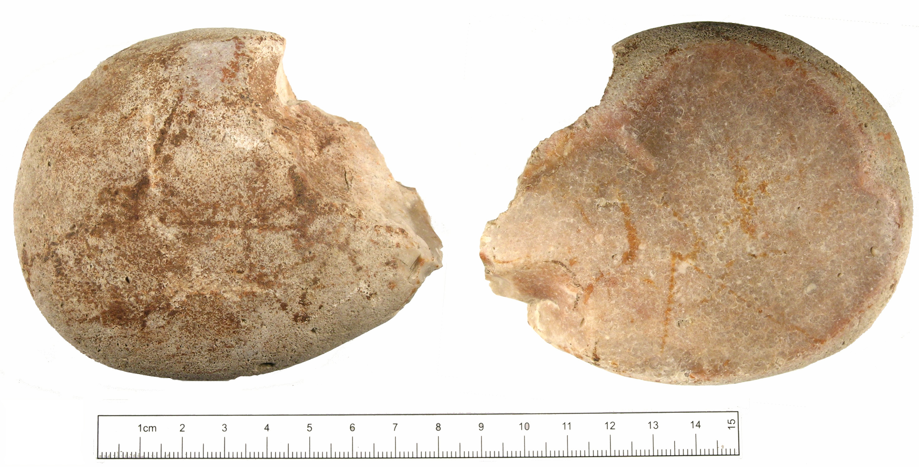
English: Utilised chert beach pebble. The stone is oval and domed with a flat base; about one quarter is missing from one side from a rough fracture. It is light creamy grey in colour with red iron staining. It is 92.3mm long, 79.4mm wide, 30.1mm thick and weighs 276grams. The base of the stone is flat and polished smooth and is covered in very small impact circles where it has been hit against something, this may have happened at the same time as the polishing or later. A similar stone has been recorded on the database (NARC-5F4FD3) and was interpreted as linen smoother. However the amount of polish on the base of this stone and the small impact fractures may suggest it was used with a rougher material, perhaps grinding sand on skins to clean them for e.g. making vellum parchment. As cleaning and preparing skins is an activity carried out since at least the Paleolithic period it is impossible to date this find with any certainty. |
||
| Depicted place | (County of findspot) East Sussex | ||
| Date | Unknown date | ||
| Accession number |
FindID: 216175 Old ref: SUSS-BC6602 Filename: DSCN0982.JPG |
||
| Credit line |
|
||
| Source |
https://finds.org.uk/database/ajax/download/id/172160 Catalog: https://finds.org.uk/database/images/image/id/172160/recordtype/artefacts Artefact: https://finds.org.uk/database/artefacts/record/id/216175 |
||
| Permission (Reusing this file) |
Attribution-ShareAlike License version 4.0 (verified 1 December 2020) | ||
| Object location | | View this and other nearby images on: OpenStreetMap |
|---|
.jpg¶ms=050.942400_N_0000.678724_E_globe:Earth_class:object_type:object__&language=en)
Licensing
[edit].jpg&action=edit§ion=2)
This file is licensed under the Creative Commons Attribution-Share Alike 4.0 International license.
Attribution: The Portable Antiquities Scheme/ The Trustees of the British Museum
- You are free:
- to share – to copy, distribute and transmit the work
- to remix – to adapt the work
- Under the following conditions:
- attribution – You must give appropriate credit, provide a link to the license, and indicate if changes were made. You may do so in any reasonable manner, but not in any way that suggests the licensor endorses you or your use.
- share alike – If you remix, transform, or build upon the material, you must distribute your contributions under the same or compatible license as the original.
File history
Click on a date/time to view the file as it appeared at that time.
| Date/Time | Thumbnail | Dimensions | User | Comment | |
|---|---|---|---|---|---|
| current | 10:29, 3 February 2017 | | 2,950 × 1,500 (1.02 MB) | Fæ (talk | contribs) | Portable Antiquities Scheme, SUSS, FindID: 216175, unknown, page 3998, batch sort-updated count 32239 |
You cannot overwrite this file.
File usage on Commons
The following page uses this file:
.jpg)
.jpg&oldid=824368382)