File:Umayyad750ADloc-ar.png
Jump to navigation
Jump to search

Size of this preview: 800 × 487 pixels. Other resolutions: 320 × 195 pixels | 640 × 390 pixels | 1,024 × 624 pixels | 1,481 × 902 pixels.
Original file (1,481 × 902 pixels, file size: 46 KB, MIME type: image/png)
Captions
Captions
Add a one-line explanation of what this file represents
Summary
[edit]
| Description |
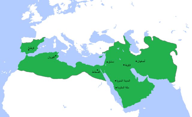
العربية: خارطة تُظهر المساحة التي امتدَّت عليها الدولة الأُمويَّة في أقصى اتساعها وذُروة قوَّتها، حوالي سنة 750م. (الرسم مبني بشكلٍ جُزئيّ على كتاب "أطلس تاريخ العالم" (2007) - العالم ما بين سنتيّ 500 و750م، الخارطة.) |
| Date | (UTC) |
| Source |
This file was derived from: Umayyad750ADloc.png: |
| Author |
|
| This is a retouched picture, which means that it has been digitally altered from its original version. Modifications: Translated to Arabic - عُرِّبت. The original can be viewed here: Umayyad750ADloc.png:
|
Licensing
[edit]
I, the copyright holder of this work, hereby publish it under the following license:
This file is licensed under the Creative Commons Attribution 3.0 Unported license.
- You are free:
- to share – to copy, distribute and transmit the work
- to remix – to adapt the work
- Under the following conditions:
- attribution – You must give appropriate credit, provide a link to the license, and indicate if changes were made. You may do so in any reasonable manner, but not in any way that suggests the licensor endorses you or your use.
Original upload log
[edit]
This image is a derivative work of the following images:
- File:Umayyad750ADloc.png licensed with Cc-by-3.0
- 2013-04-11T15:24:29Z HistoryofIran 1481x902 (30417 Bytes) {{subst:Upload marker added by en.wp UW}} {{Information |Description = {{en|Made the map more presice, the Umayyads never controlled Tabaristan because of the Dabuyid dynasty, but the Abbasids did that later.}} |Source = http
- 2013-04-10T15:55:41Z Khateeb88 1481x902 (38391 Bytes) Added the major cities of the Umayyad Caliphate: Damascus, Kufa, Isfahan, Mecca, Medina, Fustat, Kairouan, and Cordoba.
- 2013-04-10T15:54:28Z Khateeb88 1481x902 (38391 Bytes) Added the major cities of the Umayyad Caliphate: Damascus, Kufa, Isfahan, Mecca, Medina, Fustat, Kairouan, and Cordoba.
- 2009-04-22T16:17:51Z Gabagool 1481x902 (51495 Bytes) some corrections..
- 2009-04-20T16:10:54Z Gabagool 1481x902 (51573 Bytes) {{Information |Description={{en|1=Locator map for the Umayyad Caliphate at its greatest extent, c. AD 750. (Partially based on ''Atlas of World History'' (2007) - World 500-750, map.)}} |Source=Own work by uploader |Author=[
Uploaded with derivativeFX
File history
Click on a date/time to view the file as it appeared at that time.
| Date/Time | Thumbnail | Dimensions | User | Comment | |
|---|---|---|---|---|---|
| current | 13:23, 16 November 2013 | | 1,481 × 902 (46 KB) | باسم (talk | contribs) | {{Information |Description ={{en|1=map}} |Source =derevative |Author =me |Date =2013 |Permission = |other_versions = }} |
You cannot overwrite this file.
File usage on Commons
There are no pages that use this file.
File usage on other wikis
The following other wikis use this file:
- Usage on ar.wikipedia.org
- العراق
- الإسلام
- عمر بن عبد العزيز
- البصرة
- ولاية الجزائر
- القوقاز
- أبو العباس السفاح
- بوابة:التاريخ الإسلامي
- قائمة الخلفاء
- ويكيبيديا:في هذا اليوم/23 أبريل
- طريف بن مالك
- عمر بن هبيرة
- بوابة:الإمبراطورية الروسية
- بوابة:الإمبراطورية الروسية/بوابات شقيقة
- ويكيبيديا:مقالة الصفحة الرئيسية المختارة/197
- الممالك في إفريقيا قبل الاستعمار
- سعيد بن عمرو الحرشي
- بوابة:مكة/مقالة مختارة/أرشيف
- بوابة:مكة/مقالة مختارة/9
- بوابة:الأديان/تاريخ ديني/1
- بوابة:الأديان/تاريخ ديني
- قائمة السلالات الحاكمة الإسلامية
- بوابة:الإسلام/دولة مختارة
- بوابة:الإسلام/دولة مختارة/2
- بوابة:التاريخ/فقرات منوعة/أرشيف
- بوابة:التاريخ/فقرات منوعة/7
- بوابة:التاريخ الإسلامي/دولة مختارة/9
- بوابة:التاريخ الإسلامي/دولة مختارة/أرشيف
- بوابة:الإمبراطورية الألمانية
- بوابة:الإمبراطورية الألمانية/بوابات شقيقة
- بوابة:إمبراطورية اليابان
- بوابة:إمبراطورية اليابان/بوابات شقيقة
- بوابة:الخلافة الراشدة
- بوابة:الدولة الأموية
- بوابة:الدولة الأموية/واجهة
- مستخدم:عبد المؤمن/مصور/تاريخ إسلامي
- ويكيبيديا:بوابة اليوم المختارة/الأرشيف
- بوابة:الإمبراطورية الفرنسية الأولى/بوابات شقيقة
- بوابة:الإمبراطورية الفرنسية الأولى
- بوابة:الإمبراطورية النمساوية/بوابات شقيقة
- بوابة:الإمبراطورية النمساوية
- بوابة:العالم الإسلامي/مقالة مختارة/أرشيف
- بوابة:العالم الإسلامي/مقالة مختارة/1
- بوابة:العالم الإسلامي
- قالب:مواضيع متعلقة 3
- قالب:مواضيع متعلقة 3/شرح
- بوابة:العالم الإسلامي/تاريخ
- بوابة:العالم الإسلامي/مواضيع متعلقة
- بوابة:الإمبراطورية البريطانية
- بوابة:الإمبراطورية البريطانية/بوابات شقيقة
View more global usage of this file.
Metadata
Categories:
- Egypt in the 8th century
- Maps of the Umayyad Caliphate (Damascus)
- Locator maps of former countries of Europe
- Locator maps of former countries of Asia
- Locator maps of former countries of Africa
- Maps of the history of Algeria
- Maps of the history of Morocco
- Maps of the history of Portugal
- Maps of the Wilayah of Al-Andalus
- Maps showing the 750s
- Fustat
- Arabic-language maps