File:Ukvme S56 1940.jpg

Original file (10,204 × 7,837 pixels, file size: 14.25 MB, MIME type: image/jpeg)
Captions
Captions
| Übersichtskarte von Mitteleuropa 1 : 300 000 (Lithuanian part) | ||||
|---|---|---|---|---|
| Maps of 1900 | ||||
| Libau | Riga | Jakobstadt | ||
| Tilsit | Szawle | Wiłkomierz | Dwinsk | |
| Kowno | Wilna | |||
| Grodno | Slonim | |||
| Maps of 1940 | ||||
| Libau | Riga | Jakobstadt | ||
| Tilsit | Schaulen | Wilkomir | Dünaburg | |
| Ebenrode | Wilna | |||
| Grodno | Slonim | |||
| Maps of 1943 | ||||
| Libau | Riga | Jakobstadt | ||
| Tilsit | Schaulen | Wilkomir | Dünaburg | |
| Ebenrode | Wilna | |||
| Grodno | Slonim | |||
Summary
[edit]
| Warning | The original file is very high-resolution. It might not load properly or could cause your browser to freeze when opened at full size. |
|---|
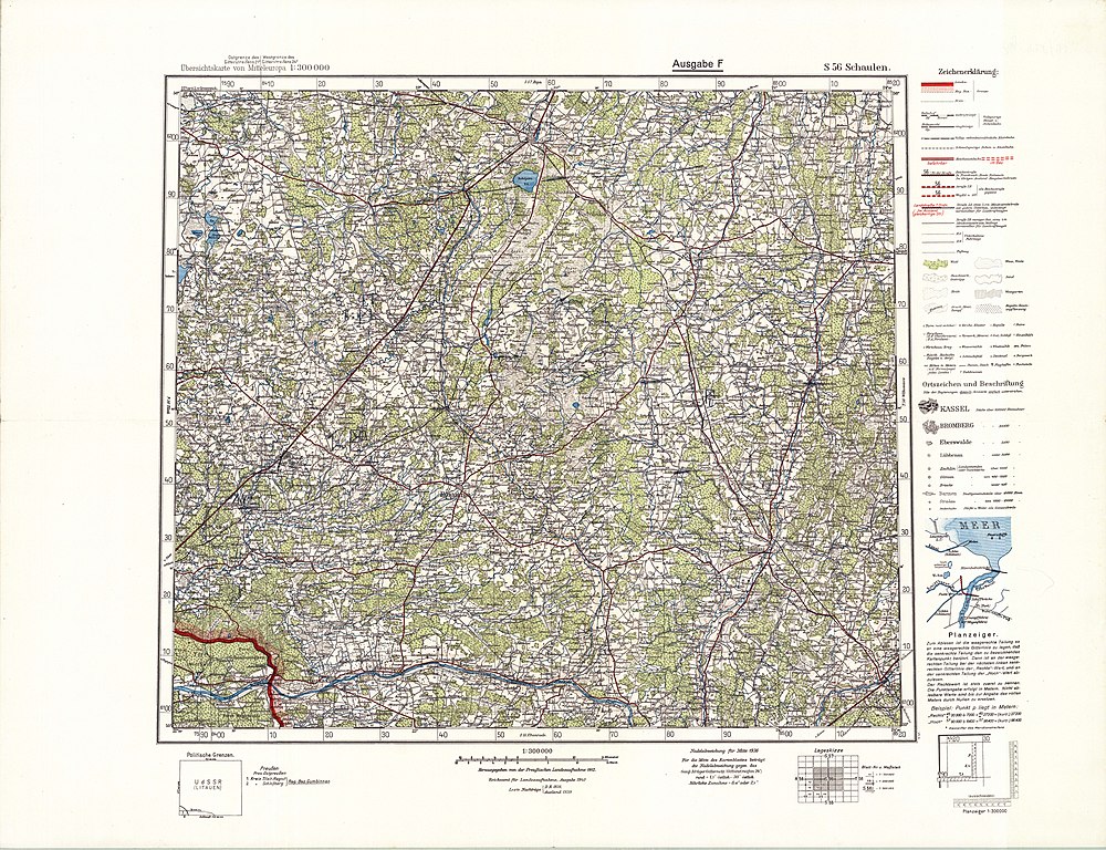
| Description | Übersichtskarte von Mitteleuropa, part Schaulen | ||||
| Date | |||||
| Source | https://lietuvai.lt/wiki/Vaizdas:DHK_300_Schaulen.jpg | ||||
| Author | Reichsamt für Landesaufnahme | ||||
| Permission (Reusing this file) |
|
||||
File history
Click on a date/time to view the file as it appeared at that time.
| Date/Time | Thumbnail | Dimensions | User | Comment | |
|---|---|---|---|---|---|
| current | 05:44, 4 November 2021 | | 10,204 × 7,837 (14.25 MB) | CD (talk | contribs) | {{Information |Description=Übersichtskarte von Mitteleuropa, part Schaulen |Source=https://lietuvai.lt/wiki/Vaizdas:DHK_300_Schaulen.jpg |Author=Reichsamt für Landesaufnahme |Date=1940 |Permission={{PD-old}} |other_versions= }} Category:Übersichtskarte von Mitteleuropa |
You cannot overwrite this file.
File usage on Commons
There are no pages that use this file.
File usage on other wikis
The following other wikis use this file:
- Usage on lt.wikipedia.org
Metadata
- Übersichtskarte von Mitteleuropa
- Aukštiškiai train station in maps
- Baisogala train station in maps
- Batakiai train station in maps
- Berčiūnai train station in maps
- Bernotiškė train station in maps
- Dotnuva train station in maps
- Dvarninkai train station in maps
- Eigirdžiai train station in maps
- Eržvilkas train station in maps
- Gaižiūnai train station in maps
- Gimbogala train station in maps
- Gubernija train station in maps
- Gudžiūnai train station in maps
- Jonava train station in maps
- Juodpetriai train station in maps
- Kėdainiai train station in maps
- Kutiškiai train station in maps
- Kužiai train station in maps
- Laba train station in maps
- Lybiškiai train station in maps
- Lyduvėnai train station in maps
- Linkaičiai train station in maps
- Pakruojis train station in maps
- Patyreliai train station in maps
- Pavilkijys train station in maps
- Radviliškis train station in maps
- Sidariai train station in maps
- Skėmiai train station in maps
- Slikiai train station in maps
- Smalininkai train station in maps
- Stačiūnai train station in maps
- Steponiškė train station in maps
- Šeduva train station in maps
- Šiauliai train station in maps
- Šienlaukis train station in maps
- Šilėnai train station in maps
- Šukioniai train station in maps
- Tytuvėnai train station in maps
- Toliočiai train station in maps
- Tryškiai train station in maps
- Ubiškė train station in maps
- Užpelkiai train station in maps
- Viduklė train station in maps
- Žeimiai train station in maps