File:Uebersicht-OH.png
Jump to navigation
Jump to search

Size of this preview: 467 × 599 pixels. Other resolutions: 187 × 240 pixels | 570 × 731 pixels.
Original file (570 × 731 pixels, file size: 15 KB, MIME type: image/png)
Captions
Captions
Add a one-line explanation of what this file represents
Summary
[edit]
| Description |
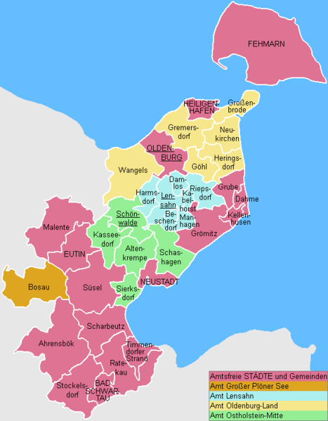
English: This map shows the Ämter (counties) and Gemeinden (municipalities) in the Kreis (district) Ostholstein in Schleswig-Holstein, Germany.
Deutsch: Diese Karte zeigt die Ämter und Gemeinden im Kreis Ostholstein, Schleswig-Holstein, Deutschland. |
| Date |
|
| Source | Own work |
| Author | ClausG |
| Permission (Reusing this file) |
GFDL |
Licensing
[edit]
I, the copyright holder of this work, hereby publish it under the following licenses:

|
Permission is granted to copy, distribute and/or modify this document under the terms of the GNU Free Documentation License, Version 1.2 or any later version published by the Free Software Foundation; with no Invariant Sections, no Front-Cover Texts, and no Back-Cover Texts. A copy of the license is included in the section entitled GNU Free Documentation License. |
| This file is licensed under the Creative Commons Attribution-Share Alike 3.0 Unported license. | ||
| ||
| This licensing tag was added to this file as part of the GFDL licensing update. |
You may select the license of your choice.
File history
Click on a date/time to view the file as it appeared at that time.
| Date/Time | Thumbnail | Dimensions | User | Comment | |
|---|---|---|---|---|---|
| current | 13:35, 31 December 2007 | | 570 × 731 (15 KB) | ClausG (talk | contribs) | Changes for 2008/01/01 |
| 15:19, 31 December 2006 |  | 570 × 731 (14 KB) | ClausG (talk | contribs) | ||
| 14:12, 9 December 2006 |  | 570 × 731 (14 KB) | ClausG (talk | contribs) | ||
| 14:07, 9 December 2006 |  | 570 × 731 (14 KB) | ClausG (talk | contribs) | == Beschreibung == {{Information |Description={{en|This map shows the Ämter (counties) and Gemeinden (municipalities) in the Kreis (district) Ostholstein in Schleswig-Holstein, Germany.}} {{de|Diese Karte zeigt die Ämter und Gemeinden im Kreis Ostholste |
You cannot overwrite this file.
File usage on Commons
There are no pages that use this file.
File usage on other wikis
The following other wikis use this file:
- Usage on da.wikipedia.org
- Usage on de.wikipedia.org
- Usage on de.wikivoyage.org
- Usage on en.wikipedia.org
- Usage on es.wikipedia.org
- Usage on fa.wikipedia.org
- Usage on frr.wikipedia.org
- Usage on fr.wikipedia.org
- Usage on it.wikipedia.org
- Usage on ms.wikipedia.org
- Usage on nl.wikipedia.org
- Usage on no.wikipedia.org
- Usage on pl.wikipedia.org
- Usage on pt.wikipedia.org
- Usage on ro.wikipedia.org
- Usage on simple.wikipedia.org
- Usage on tr.wikipedia.org
- Usage on uk.wikipedia.org
- Usage on vi.wikipedia.org