File:Uaxactun, Palace A-18 (15958078792).jpg

Original file (5,184 × 3,456 pixels, file size: 12.59 MB, MIME type: image/jpeg)
Captions
Captions
Summary
[edit].jpg&action=edit§ion=1)
| Description |
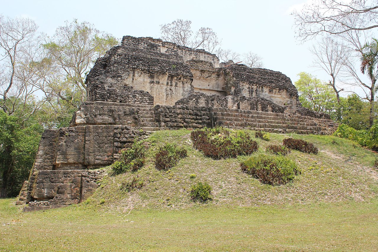
Uaxactun, Palace A-18 Uaxactun is an ancient sacred place of the Maya civilization, located in the Petén Basin region of the Maya lowlands, in the present-day department of Petén, Guatemala. The site lies some 19 km north of the major center of Tikal. A number of ceremonial buildings were erected before the end of the Late Pre Classic Period and the beginning of the Classic. Structure A-XVIII is located in the north-east corner of the acropolis and faces south on the East Plaza. The building, one of the highest at Uaxactun, rests on a steep, rectangular platform-mound which rises in two narrow terraces with nearly vertical sides. It has two stories, the upper one reached by an interior stairway. The lower story consists of three parallel galleries running east and west, of which the front, or southernmost, has largely fallen. The middle gallery is intact except for the doorway and the vault directly above it; the northern gallery is complete. At either end of these galleries are small rooms, several of which have a north-south axis. Entrance to the lower rooms was gained by three doorways on the south and one on the east. The upper story consisted of two galleries over the two northernmost lower galleries. Over the southern lower gallery was a broad terrace. This, as well as all the construction above the spring of the arch of the upper rooms, has fallen. With the exception of the terrace, the upper story conformed almost exactly in plan to the lower. Between the medial molding and the cornice the façade was decorated with large stucco masks. Parts of only seven masks remain, but there is little doubt that originally there were fourteen, five on the north and south sides and two at either end. (source: en.wikipedia.org/wiki/Uaxactun, www.mesoweb.com/publications/CAA_20/CAA_No20.pdf) |
| Date | |
| Source | Uaxactun, Palace A-18 |
| Author | Arian Zwegers from Brussels, Belgium |
| Camera location | | View this and other nearby images on: OpenStreetMap |
|---|
.jpg¶ms=017.395236_N_-089.637929_E_globe:Earth_type:camera_source:Flickr_&language=en)
Licensing
[edit].jpg&action=edit§ion=2)
- You are free:
- to share – to copy, distribute and transmit the work
- to remix – to adapt the work
- Under the following conditions:
- attribution – You must give appropriate credit, provide a link to the license, and indicate if changes were made. You may do so in any reasonable manner, but not in any way that suggests the licensor endorses you or your use.
| This image was originally posted to Flickr by Arian Zwegers at https://flickr.com/photos/67769030@N07/15958078792. It was reviewed on 29 May 2016 by FlickreviewR and was confirmed to be licensed under the terms of the cc-by-2.0. |
File history
Click on a date/time to view the file as it appeared at that time.
| Date/Time | Thumbnail | Dimensions | User | Comment | |
|---|---|---|---|---|---|
| current | 18:39, 29 May 2016 | | 5,184 × 3,456 (12.59 MB) | Moheen (talk | contribs) | {{Information |Description=Uaxactun, Palace A-18 Uaxactun is an ancient sacred place of the Maya civilization, located in the Petén Basin region of the Maya lowlands, in the present-day department of Petén, Guatemala. The site lies some 19 km north... |
You cannot overwrite this file.
File usage on Commons
There are no pages that use this file.
File usage on other wikis
The following other wikis use this file:
- Usage on pl.wikipedia.org
.jpg&oldid=891706714)