File:US Navy 051019-N-1234W-002 Graphic produced by the U.S. Navy, Atlantic Meteorology ^ Oceanography Center, Norfolk, Va., showing the anticipated track of Hurricane Wilma.jpg
Jump to navigation
Jump to search

Size of this preview: 800 × 570 pixels. Other resolutions: 320 × 228 pixels | 640 × 456 pixels | 1,024 × 729 pixels | 1,272 × 906 pixels.
Original file (1,272 × 906 pixels, file size: 409 KB, MIME type: image/jpeg)
Captions
Captions
Add a one-line explanation of what this file represents
Summary
[edit]| Description |
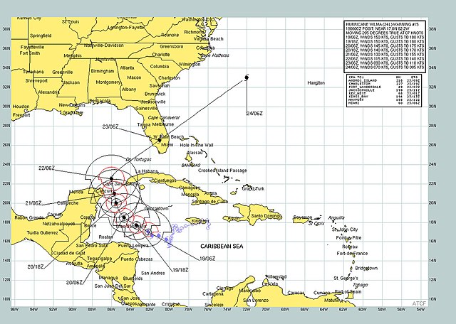
English: Caribbean Sea (Oct. 19, 2005) - Graphic produced by the U.S. Navy, Atlantic Meteorology & Oceanography Center, Norfolk, Va., showing the anticipated track of Hurricane Wilma. An Air force reconnaissance plane reported a barometric pressure reading of 884 mb. This is the lowest minimum pressure ever measured in a hurricane in the Atlantic Basin. A hurricane watch remains in effect in Cuba. All interests in the Florida Keys and the Florida Peninsula should closely monitor the progress of extremely dangerous Hurricane Wilma. At 5 AM EDT 0900z the center of Wilma was located near Latitude 17.2 north longitude 82.5 west or about 170 miles south-southwest of Grand Cayman and about 365 miles southeast of Cozumel, Mexico. Wilma is moving toward the west-northwest near 8. A Turn toward the northwest is expected during the next 24 hours. Maximum sustained winds are near 175 mph with higher gusts. Wilma is a catastrophic category five hurricane on the Saffir-simpson scale. Some fluctuations in intensity are expected U.S. Navy photo (RELEASED) For more information visit: <a href="http://www.nrlmry.navy.mil" Target="_BLANK">www.nrlmry.navy.mil</a> |
|||
| Date | Taken on 19 October 2005 | |||
| Source |
|
|||
| Author | U.S. Navy photo |

Licensing
[edit]
This file is a work of a sailor or employee of the U.S. Navy, taken or made as part of that person's official duties. As a work of the U.S. federal government, it is in the public domain in the United States.
|
 | |
| This file has been identified as being free of known restrictions under copyright law, including all related and neighboring rights. | ||
File history
Click on a date/time to view the file as it appeared at that time.
| Date/Time | Thumbnail | Dimensions | User | Comment | |
|---|---|---|---|---|---|
| current | 09:01, 23 October 2009 | | 1,272 × 906 (409 KB) | BotMultichillT (talk | contribs) | == {{int:filedesc}} == {{Information |description={{en|1=Carribean Sea (Oct. 19, 2005) - Graphic produced by the U.S. Navy, Atlantic Meteorology & Oceanography Center, Norfolk, Va., showing the anticipated track of Hurricane Wilma. An Air force reconnaiss |
You cannot overwrite this file.
File usage on Commons
There are no pages that use this file.