File:US Navy 040909-N-0000X-003 Satellite image taken from the GOES-12 satellite of Hurricane Ivan at approximately 0815 EST.jpg
Jump to navigation
Jump to search

Size of this preview: 600 × 600 pixels. Other resolutions: 240 × 240 pixels | 480 × 480 pixels | 768 × 768 pixels | 1,024 × 1,024 pixels.
Original file (1,024 × 1,024 pixels, file size: 249 KB, MIME type: image/jpeg)
Captions
Captions
Add a one-line explanation of what this file represents
Summary
[edit]| Description |
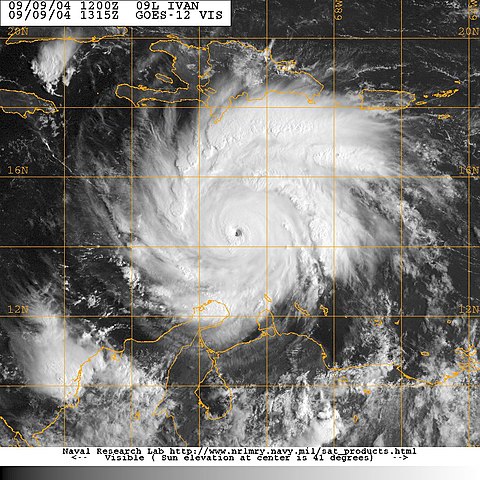
English: Caribbean Sea (Sept. 9, 2004) – Satellite image taken from the GOES-12 satellite of Hurricane Ivan at approximately 0815 EST. Ivan, an extremely dangerous category five hurricane on the Saffir-Simpson Hurricane scale has maximum sustained winds near 160 mph with higher gusts. Hurricane force winds extend outward up to 60 miles from the center and tropical storm force winds extend outward up to 160 miles. The well-defined eye of hurricane Ivan was located about 455 miles southeast of Kingston Jamaica. Storm surge flooding of three to five feet above normal tide levels along with large and dangerous battering waves can be expected near the center of Ivan in the hurricane warning area. Rainfall amounts of five to seven inches and could possibly cause life-threatening flash floods and mud slides. Hurricane Ivan has killed at least 15 people in Grenada, Tobago and Venezuela as it barrels toward Jamaica. Photo provided by Naval Atlantic Meteorology and Oceanography Center (RELEASED) For more information visit <a href="https://weather.navy.mil" Target="_BLANK">https://weather.navy.mil</a> |
|||
| Date | ||||
| Source |
|
|||
| Author | U.S. Navy photo |

Licensing
[edit]
This file is a work of a sailor or employee of the U.S. Navy, taken or made as part of that person's official duties. As a work of the U.S. federal government, it is in the public domain in the United States.
|
 | |
| This file has been identified as being free of known restrictions under copyright law, including all related and neighboring rights. | ||
File history
Click on a date/time to view the file as it appeared at that time.
| Date/Time | Thumbnail | Dimensions | User | Comment | |
|---|---|---|---|---|---|
| current | 13:44, 23 October 2009 | | 1,024 × 1,024 (249 KB) | BotMultichillT (talk | contribs) | == {{int:filedesc}} == {{Information |description={{en|1=Caribbean Sea (Sept. 9, 2004) – Satellite image taken from the GOES-12 satellite of Hurricane Ivan at approximately 0815 EST. Ivan, an extremely dangerous category five hurricane on the Saffir |
You cannot overwrite this file.
File usage on Commons
There are no pages that use this file.