File:USGS topo Map-Centerville Borough below Malden, Denbo Heights to West Brownsville Washington County Pennsylvania with PA-43, US-40 & Old National Road.png

Original file (1,780 × 1,030 pixels, file size: 4.4 MB, MIME type: image/png)
Captions
Captions
Summary
[edit]
| Description |
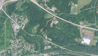
English: One of three Topographic maps showing terrain between West Brownsville, PA and Malden, Pennsylvania to demonstrate terrain and road network changes with respect to the National Road since it was initially paved: • This map details the relative lack of roadside flat-areas along the (historic old wagon road) later designated US 40 (US Route 40). The topology of the series shows that the National Road had few places where immigrants, weary from descending through the perils of the wagon road from Uniontown, PA, had few or no places to pull over and rest or make camp. Once they'd reached the approaches to Brownsville Heights (aka Redstone Heights) about two miles east of the trun in Market Street (Today's Lane Bane Bridge abutments) — until they traveled the five miles or so (perhaps a full half-days travel) — until the family's Conestoga wagon reached the flat areas near the Malden Inn in Washington County, Pennsylvania. • This map in the series shows the community of Denbo Heights (lower left corner) & its intersection and approach road from Old US 40/National Road; also seen are the Monongahela River, railroad tracks and Lowhill Road (PA Route 88) along the bottom — while where Old US 40 and PA 88 converge along the river (bottom right) is the end of the descent (eastwards) on the outskirts of West Brownsville, PA. • Visible in the upper left corner: Highway PA 43, the north-south toll road once planned to connect Pittsburgh to Morgantown, WV is a highway it took several decades of funding struggles to gradually advance. It has yet to reach West Virginia. Others in this series & upload: |
|||
| Date | ||||
| Source | USGS GNIS system & National Map Viewer | |||
| Author | Captured, processed, edited and uploaded by User: Fabartus | |||
| Permission (Reusing this file) |
|
|||
| Other versions |
Others in this series & upload:  |
| Camera location | | View this and other nearby images on: OpenStreetMap |
|---|
Lat/Lng according to USGS GNIS system for Malden, Pennsylvania 40° 1′ 17.4″ N, 79° 33′ 33″ W or (40.0215, -79.559167). The area of the image differs on its centering.
Licensing
[edit]
This work is in the public domain in the United States because it is a work prepared by an officer or employee of the United States Government as part of that person’s official duties under the terms of Title 17, Chapter 1, Section 105 of the US Code.
Note: This only applies to original works of the Federal Government and not to the work of any individual U.S. state, territory, commonwealth, county, municipality, or any other subdivision. This template also does not apply to postage stamp designs published by the United States Postal Service since 1978. (See § 313.6(C)(1) of Compendium of U.S. Copyright Office Practices). It also does not apply to certain US coins; see The US Mint Terms of Use.
|
 | |
| This file has been identified as being free of known restrictions under copyright law, including all related and neighboring rights. | ||
File history
Click on a date/time to view the file as it appeared at that time.
| Date/Time | Thumbnail | Dimensions | User | Comment | |
|---|---|---|---|---|---|
| current | 17:56, 16 December 2016 | | 1,780 × 1,030 (4.4 MB) | Fabartus (talk | contribs) | User created page with UploadWizard |
You cannot overwrite this file.
File usage on Commons
The following 2 pages use this file: