File:USGS orthophoto of North Brother Island and South Brother Island - Bronx County.png
Jump to navigation
Jump to search

Size of this preview: 308 × 600 pixels. Other resolutions: 123 × 240 pixels | 246 × 480 pixels | 846 × 1,648 pixels.
Original file (846 × 1,648 pixels, file size: 1.77 MB, MIME type: image/png)
Captions
Captions
Add a one-line explanation of what this file represents
Summary
[edit]
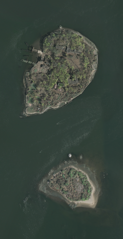
| Description | |
| Date | Acquired in march 2006; published by USGS in 2008; converted and uploaded to Commons on April 22, 2009. |
| Source |
The National Map Seamless Server, layer New York City (Mar 2006), latitude 40.79433919 to 40.80337576, longitude -73.90149724 to -73.89540822. Converted from GeoTIFF to PNG using GIMP. |
| Author | U.S. Geological Survey, conversion to PNG by uploader (Herr Satz). |
Licensing
[edit]
This image is in the public domain in the United States because it only contains materials that originally came from the United States Geological Survey, an agency of the United States Department of the Interior. For more information, see the official USGS copyright policy.
|
File history
Click on a date/time to view the file as it appeared at that time.
| Date/Time | Thumbnail | Dimensions | User | Comment | |
|---|---|---|---|---|---|
| current | 17:04, 22 April 2009 | | 846 × 1,648 (1.77 MB) | Herr Satz (talk | contribs) | {{Information |Description={{en|1=Orthophoto of North Brother and South Brother islands.}} |Source=[http://gisdata.usgs.net/website/seamless/viewer.htm ''The National Map'' Seamless Se |
You cannot overwrite this file.
File usage on Commons
The following page uses this file:
- File:USGS North Brother &South Brother islands.png (file redirect)
File usage on other wikis
The following other wikis use this file:
- Usage on de.wikipedia.org
- Usage on es.wikipedia.org
- Usage on et.wikipedia.org
- Usage on fr.wikipedia.org
- Usage on he.wikipedia.org