File:USGS Lake Superior syncline.png
Jump to navigation
Jump to search
Size of this preview: 800 × 539 pixels. Other resolutions: 320 × 216 pixels | 640 × 432 pixels | 1,007 × 679 pixels.
Original file (1,007 × 679 pixels, file size: 603 KB, MIME type: image/png)
Captions
Captions
Add a one-line explanation of what this file represents
Summary
[edit]
| Description |
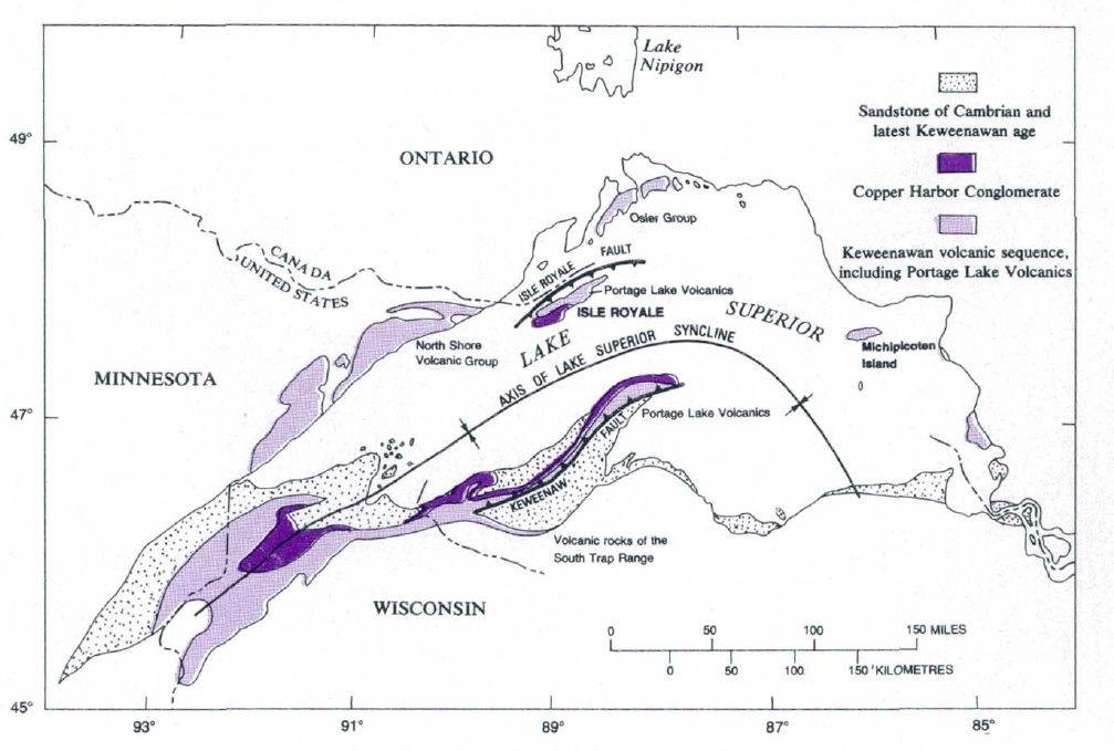
English: USGS Lake Superior syncline |
| Date | |
| Source | The Geologic Story of Isle Royale National Park, USGS Bulletin 1309 |
| Author | N. King Huber |
Licensing
[edit]
This work is in the public domain in the United States because it is a work prepared by an officer or employee of the United States Government as part of that person’s official duties under the terms of Title 17, Chapter 1, Section 105 of the US Code.
Note: This only applies to original works of the Federal Government and not to the work of any individual U.S. state, territory, commonwealth, county, municipality, or any other subdivision. This template also does not apply to postage stamp designs published by the United States Postal Service since 1978. (See § 313.6(C)(1) of Compendium of U.S. Copyright Office Practices). It also does not apply to certain US coins; see The US Mint Terms of Use.
|
 | |
| This file has been identified as being free of known restrictions under copyright law, including all related and neighboring rights. | ||
File history
Click on a date/time to view the file as it appeared at that time.
| Date/Time | Thumbnail | Dimensions | User | Comment | |
|---|---|---|---|---|---|
| current | 16:18, 7 May 2017 | | 1,007 × 679 (603 KB) | Pi3.124 (talk | contribs) | User created page with UploadWizard |
You cannot overwrite this file.
File usage on Commons
There are no pages that use this file.
File usage on other wikis
The following other wikis use this file:
- Usage on en.wikipedia.org
- Usage on zh.wikipedia.org
Metadata
Categories:
- Geological maps of North America
- Keweenaw Peninsula
- Geological maps of Michigan
- Geological maps of Isle Royale National Park
- Geology of Michigan
- Geology of Wisconsin
- Geology of Minnesota
- Geology of Ontario
- Maps of synclines
- Copper Harbor Conglomerate
- Portage Lake Volcanic Series maps
- Cambrian sandstone
- Faults in North America
- Cambrian sandstone in Ontario