File:USGS 1920 Sketch map showing roads in vicinity of Dale, Twenty-Nine Palms, and Pinyon (Piñon) Well, California.jpg
Jump to navigation
Jump to search
Size of this preview: 800 × 379 pixels. Other resolutions: 320 × 151 pixels | 640 × 303 pixels | 1,024 × 485 pixels | 1,280 × 606 pixels | 2,684 × 1,270 pixels.
Original file (2,684 × 1,270 pixels, file size: 1.15 MB, MIME type: image/jpeg)
Captions
Captions
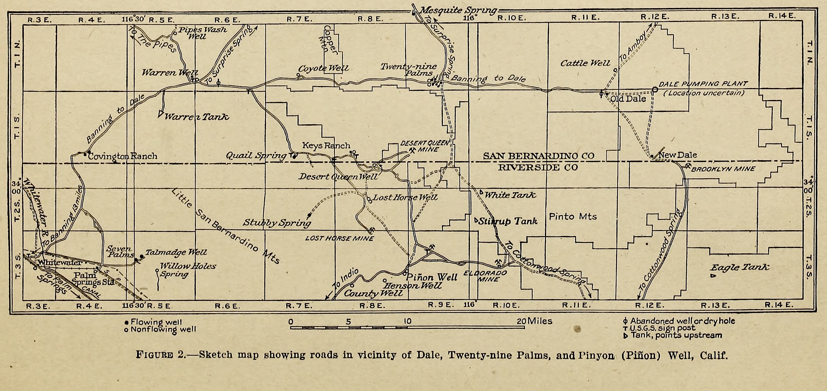
USGS 1920 Sketch map showing roads in vicinity of Dale, Twenty-Nine Palms, and Pinyon (Piñon) Well, California
Summary
[edit]_Well,_California.jpg&action=edit§ion=1)
| Description |
English: Sketch map showing roads in vicinity of Dale, Twenty-Nine Palms, and Pinyon (Piñon) Well, California |
| Date | |
| Source |
Routes to desert watering places in the Salton Sea Region, California Water Supply Paper 490-A By: John Stafford Brown https://doi.org/10.3133/wsp490A |
| Author | USGS |
Licensing
[edit]_Well,_California.jpg&action=edit§ion=2)
This work is in the public domain in the United States because it is a work prepared by an officer or employee of the United States Government as part of that person’s official duties under the terms of Title 17, Chapter 1, Section 105 of the US Code.
Note: This only applies to original works of the Federal Government and not to the work of any individual U.S. state, territory, commonwealth, county, municipality, or any other subdivision. This template also does not apply to postage stamp designs published by the United States Postal Service since 1978. (See § 313.6(C)(1) of Compendium of U.S. Copyright Office Practices). It also does not apply to certain US coins; see The US Mint Terms of Use.
|
 | |
| This file has been identified as being free of known restrictions under copyright law, including all related and neighboring rights. | ||
File history
Click on a date/time to view the file as it appeared at that time.
| Date/Time | Thumbnail | Dimensions | User | Comment | |
|---|---|---|---|---|---|
| current | 00:53, 12 December 2023 | | 2,684 × 1,270 (1.15 MB) | Jengod (talk | contribs) | Uploaded a work by USGS from pubs.usgs.gov with UploadWizard |
You cannot overwrite this file.
File usage on Commons
There are no pages that use this file.
_Well,_California.jpg&oldid=831264495)