File:USA Map 1864 including Civil War Divisions.png
Jump to navigation
Jump to search
No higher resolution available.
USA_Map_1864_including_Civil_War_Divisions.png (784 × 488 pixels, file size: 25 KB, MIME type: image/png)
Captions
Captions
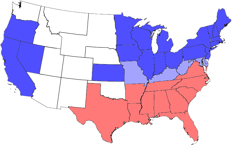
Division of states during the civil war: blue = Union, including those admitted during the war; light blue = border, some of which had both Unionist & Confederate governments; red = Confederate; white areas were not states before or during the war.
Summary
[edit]

|
This locator map image could be re-created using vector graphics as an SVG file. This has several advantages; see Commons:Media for cleanup for more information. If an SVG form of this image is available, please upload it and afterwards replace this template with
{{vector version available|new image name}}.
It is recommended to name the SVG file “USA Map 1864 including Civil War Divisions.svg”—then the template Vector version available (or Vva) does not need the new image name parameter. |
from one on Wikipedia. All blue areas represent Union states, including those admitted during the war; light blue areas represent Union states which permitted slavery; red areas represent Confederate states.
Note: West Virginia became a state during the Civil War
Licensing
[edit]
I, the copyright holder of this work, hereby publish it under the following licenses:

|
Permission is granted to copy, distribute and/or modify this document under the terms of the GNU Free Documentation License, Version 1.2 or any later version published by the Free Software Foundation; with no Invariant Sections, no Front-Cover Texts, and no Back-Cover Texts. A copy of the license is included in the section entitled GNU Free Documentation License. |
| This file is licensed under the Creative Commons Attribution-Share Alike 3.0 Unported license. | ||
| ||
| This licensing tag was added to this file as part of the GFDL licensing update. |
You may select the license of your choice.
File history
Click on a date/time to view the file as it appeared at that time.
| Date/Time | Thumbnail | Dimensions | User | Comment | |
|---|---|---|---|---|---|
| current | 20:14, 3 July 2006 | | 784 × 488 (25 KB) | Tom (talk | contribs) | adjusting colors and formatting |
| 04:12, 24 August 2005 |  | 812 × 503 (34 KB) | Tom (talk | contribs) | {{GFDL}} United States Civil War Division in 1864 - slightly modified from one on Wikipedia. |
You cannot overwrite this file.
File usage on Commons
There are no pages that use this file.
File usage on other wikis
The following other wikis use this file:
- Usage on als.wikipedia.org
- Usage on az.wikipedia.org
- Usage on be.wikipedia.org
- Usage on bg.wikipedia.org
- Usage on br.wikipedia.org
- Usage on ca.wikipedia.org
- Usage on ckb.wikipedia.org
- Usage on co.wikipedia.org
- Usage on da.wikipedia.org
- Usage on de.wikipedia.org
- Sezessionskrieg
- Südstaaten
- Benutzer:Ralf Reinartz/Vorlagen
- Wikipedia:Bücher/Geschichte der USA: Bürgerkrieg und Reconstruction
- Postgeschichte und Briefmarken der Vereinigten Staaten
- Wikipedia Diskussion:Hauptseite/Artikel des Tages/Archiv/Vorschläge/2014/Q1
- Wikipedia:Hauptseite/Archiv/2. Januar 2014
- Benutzer:LDV-E8
- Usage on de.wikiversity.org
- Usage on el.wikipedia.org
- Usage on en.wikipedia.org
- Usage on en.wiktionary.org
- Usage on es.wikipedia.org
- Usage on et.wikipedia.org
- Usage on fa.wikipedia.org
- Usage on frr.wikipedia.org
- Usage on fr.wikipedia.org
- Usage on he.wikipedia.org
- Usage on hr.wikipedia.org
- Usage on hu.wikipedia.org
- Usage on incubator.wikimedia.org
- Usage on ja.wikipedia.org
View more global usage of this file.