File:US62NewYorkRoute.jpg
Jump to navigation
Jump to search

Size of this preview: 450 × 600 pixels. Other resolutions: 180 × 240 pixels | 360 × 480 pixels | 576 × 768 pixels | 1,200 × 1,600 pixels.
Original file (1,200 × 1,600 pixels, file size: 493 KB, MIME type: image/jpeg)
Captions
Captions
Add a one-line explanation of what this file represents
Summary
[edit]
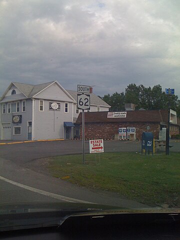
Image of U.S. Route 62 using a New York State Route shield instead of a U.S. Route shield. There were several of these throughout Niagara County, New York, this one is in Wheatfield, New York.
Licensing
[edit]
| I, the copyright holder of this work, release this work into the public domain. This applies worldwide. In some countries this may not be legally possible; if so: I grant anyone the right to use this work for any purpose, without any conditions, unless such conditions are required by law. |
File history
Click on a date/time to view the file as it appeared at that time.
| Date/Time | Thumbnail | Dimensions | User | Comment | |
|---|---|---|---|---|---|
| current | 16:03, 5 July 2009 | | 1,200 × 1,600 (493 KB) | Jgera5 (talk | contribs) | Image of U.S. Route 62 using a New York State Route shield instead of a U.S. Route shield. There were several of these throughout Niagara County, New York, this one I believe was in Niagara Falls, New York. (Correct me if I'm wrong, I'm not from New York. |
You cannot overwrite this file.
File usage on Commons
The following page uses this file:
File usage on other wikis
The following other wikis use this file:
- Usage on en.wikipedia.org