File:Typhoonsizes.svg
Jump to navigation
Jump to search

Size of this PNG preview of this SVG file: 800 × 508 pixels. Other resolutions: 320 × 203 pixels | 640 × 406 pixels | 1,024 × 650 pixels | 1,280 × 812 pixels | 2,560 × 1,625 pixels | 3,000 × 1,904 pixels.
Original file (SVG file, nominally 3,000 × 1,904 pixels, file size: 764 KB)
Captions
Captions
Add a one-line explanation of what this file represents
Summary
[edit]
| Description |
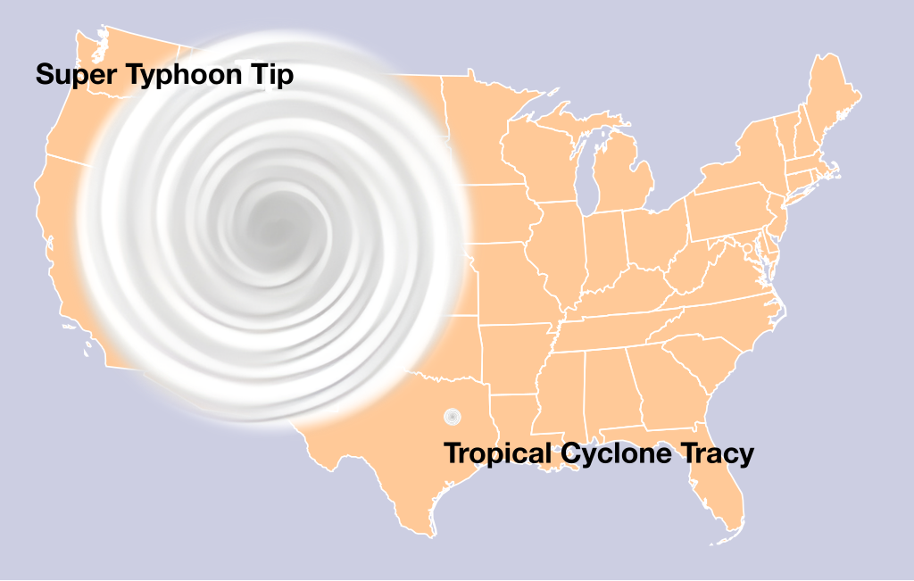
English: An illustration of the extreme sizes of tropical cyclones. SVG replacement for File:Typhoonsizes.jpg. US map from File:Blank US Map (states only).svg. |
| Date | |
| Source | Own work |
| Author | Morn |
.svg)
Licensing
[edit]
I, the copyright holder of this work, hereby publish it under the following license:
| This file is made available under the Creative Commons CC0 1.0 Universal Public Domain Dedication. | |
| The person who associated a work with this deed has dedicated the work to the public domain by waiving all of their rights to the work worldwide under copyright law, including all related and neighboring rights, to the extent allowed by law. You can copy, modify, distribute and perform the work, even for commercial purposes, all without asking permission.
|
| Annotations | This image is annotated: View the annotations at Commons |
File history
Click on a date/time to view the file as it appeared at that time.
| Date/Time | Thumbnail | Dimensions | User | Comment | |
|---|---|---|---|---|---|
| current | 12:56, 3 August 2024 | | 3,000 × 1,904 (764 KB) | Morn (talk | contribs) | slightly enlarge Tracy to correct scale |
| 06:37, 1 August 2024 |  | 3,000 × 1,904 (764 KB) | Morn (talk | contribs) | wider outlines | |
| 21:52, 31 July 2024 |  | 3,000 × 1,904 (749 KB) | Morn (talk | contribs) | Uploaded own work with UploadWizard |
You cannot overwrite this file.
File usage on Commons
The following page uses this file:
File usage on other wikis
The following other wikis use this file:
- Usage on en.wikipedia.org