File:Typhoon Songda, Natural Hazards DVIDS731737.jpg

Original file (3,200 × 4,200 pixels, file size: 2.74 MB, MIME type: image/jpeg)
Captions
Captions
Summary
[edit]
| Description |
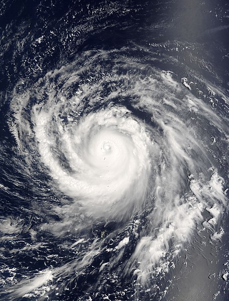
English: The MODIS instrument aboard NASA's Terra satellite captured this true-color image of Typhoon Songda on September 1, 2004 at 00:40 UTC. At the time this image was taken Songda was located approximately 740 km (460 miles) southeast of Iwo Jima, Japan and was moving towards the northwest at 28 km/hr (17 mph). Maximum sustained winds were near 232 km/hr (144 mph) with higher gusts to 278 km/hr (173 mph). The MODIS Rapid Response System provides this image at rapidfire.sci.gsfc.nasa.gov/gallery/?2004245-0901/Songda.A2004245.0040 additional resolutions and formats. NASA image courtesy Jacques Descloitres, rapidfire.sci.gsfc.nasa.gov MODIS Land Rapid Response Team at NASA GSFC. NASA Identifier: Songda_tmo2004245
|
| Date | |
| Source | https://www.dvidshub.net/image/731737/typhoon-songda-natural-hazards |
| Author | Glenn Research Center |
| Location | WASHINGTON, DC, US |
| Posted | 17 October 2012, 17:50 |
| DVIDS ID | 731737 |
| Archive link | archive copy at the Wayback Machine |
Licensing
[edit]
| This file is in the public domain in the United States because it was solely created by NASA. NASA copyright policy states that "NASA material is not protected by copyright unless noted". (See Template:PD-USGov, NASA copyright policy page or JPL Image Use Policy.) | ||
 |
Warnings:
|
File history
Click on a date/time to view the file as it appeared at that time.
| Date/Time | Thumbnail | Dimensions | User | Comment | |
|---|---|---|---|---|---|
| current | 21:56, 10 March 2017 | | 3,200 × 4,200 (2.74 MB) | Fæ (talk | contribs) | DVIDS 12 megapixel image from https://www.dvidshub.net/image/731737/typhoon-songda-natural-hazards. nasa; nasanaturalhazards. Part of User:Fæ/Project list/DoD |
You cannot overwrite this file.
File usage on Commons
There are no pages that use this file.