File:Turkish Offensive in Northern Syria.png
Jump to navigation
Jump to search

Size of this preview: 800 × 512 pixels. Other resolutions: 320 × 205 pixels | 640 × 410 pixels | 1,024 × 655 pixels | 1,280 × 819 pixels | 1,639 × 1,049 pixels.
Original file (1,639 × 1,049 pixels, file size: 222 KB, MIME type: image/png)
Captions
Captions
Add a one-line explanation of what this file represents
Summary
[edit]
Look also: User:Berkaysnklf/Turkey
.
.
| Description |
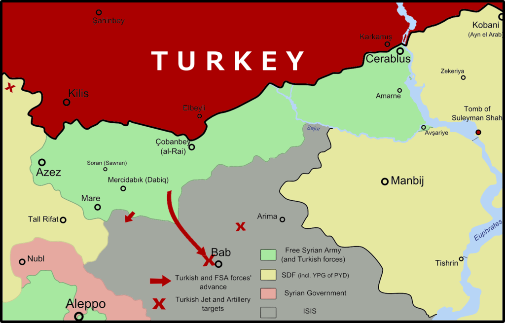
English: The current map of the latest situation of the ongoing Turkish-led offensive in Northern Syria. (Subject to updates)
Türkçe: Türk öncülüğünde yürütülen Kuzey Suriye'deki harekâtın son durumunu gösteren güncel harita. (Güncellenebilir) |
||||||
| Date | |||||||
| Source | Own work | ||||||
| Author |
|
||||||
| Permission (Reusing this file) |
|
Özgür Suriye Ordusu tarafından kontrol edilen bölge
Suriye hukümeti tarafından kontrol edilen bölge
IŞİD tarafından kontrol edilen bölge
Suriye Demokratik Güçleri tarafından kontrol edilen bölge
Licensing
[edit]
I, the copyright holder of this work, hereby publish it under the following license:
This file is licensed under the Creative Commons Attribution-Share Alike 4.0 International license.
- You are free:
- to share – to copy, distribute and transmit the work
- to remix – to adapt the work
- Under the following conditions:
- attribution – You must give appropriate credit, provide a link to the license, and indicate if changes were made. You may do so in any reasonable manner, but not in any way that suggests the licensor endorses you or your use.
- share alike – If you remix, transform, or build upon the material, you must distribute your contributions under the same or compatible license as the original.
File history
Click on a date/time to view the file as it appeared at that time.
| Date/Time | Thumbnail | Dimensions | User | Comment | |
|---|---|---|---|---|---|
| current | 18:12, 17 October 2016 | | 1,639 × 1,049 (222 KB) | BRKY24 (talk | contribs) | Territorial changes as of 17 September, 21:00 (Further-eastern European Time - UTC +3). |
| 21:15, 12 October 2016 |  | 1,639 × 1,049 (255 KB) | BRKY24 (talk | contribs) | As forces get closer to Sawran and Dabiq, updated the much-needed territorial changes. | |
| 17:22, 19 September 2016 |  | 1,639 × 1,049 (256 KB) | BRKY24 (talk | contribs) | I have added the importantly missing "Turkey" text. | |
| 15:42, 19 September 2016 |  | 1,639 × 1,049 (252 KB) | BRKY24 (talk | contribs) | Updates on territorial gains/losses. Updates on fronts. Correction of usage of PYD and its militant wing YPG. | |
| 22:43, 6 September 2016 |  | 1,639 × 1,049 (264 KB) | BRKY24 (talk | contribs) | Technical fix. | |
| 22:26, 6 September 2016 |  | 1,639 × 1,049 (264 KB) | BRKY24 (talk | contribs) | New territorial changes updated, map currently as of 6 September 2016, 23:00 (local time / UTC+3) | |
| 15:41, 4 September 2016 |  | 1,639 × 1,049 (240 KB) | Beshogur (talk | contribs) | Update! | |
| 14:27, 4 September 2016 |  | 1,639 × 1,049 (240 KB) | Beshogur (talk | contribs) | Update! | |
| 12:58, 4 September 2016 |  | 1,639 × 1,049 (242 KB) | Beshogur (talk | contribs) | Update! | |
| 21:53, 30 August 2016 |  | 1,639 × 1,049 (257 KB) | BRKY24 (talk | contribs) | Further neutralization of names. More settlements of strategic significance shown. New territorial changes as of 30 August 2016, 23:00 local time (UTC +3) updated. |
You cannot overwrite this file.
File usage on Commons
The following 8 pages use this file:
File usage on other wikis
The following other wikis use this file:
- Usage on ca.wikipedia.org
- Usage on en.wikipedia.org
- Usage on fr.wikinews.org
- Usage on it.wikipedia.org
- Usage on sv.wikipedia.org
- Usage on uk.wikipedia.org