File:Tunstall Dyke tower mill - the scoop wheel - geograph.org.uk - 822010.jpg
Jump to navigation
Jump to search
Size of this preview: 450 × 600 pixels. Other resolutions: 180 × 240 pixels | 480 × 640 pixels.
Original file (480 × 640 pixels, file size: 206 KB, MIME type: image/jpeg)
Captions
Captions
Add a one-line explanation of what this file represents
Summary
[edit]
| Description |
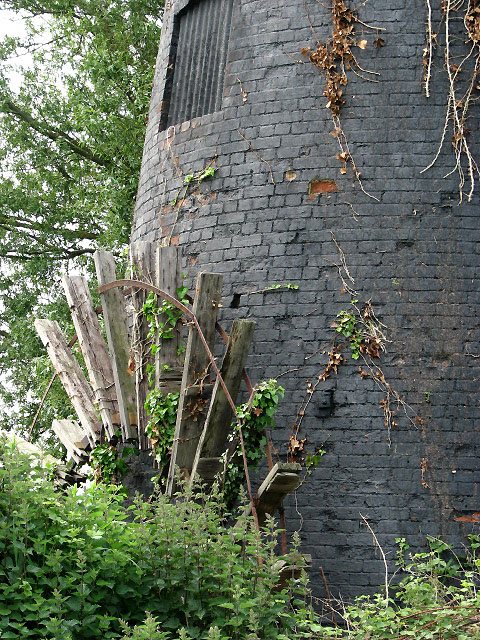
English: Tunstall Dyke tower mill - the scoop wheel. Detail of the decaying scoop wheel. Tunstall dyke tower mill > 822005 is located on an island of its own, on the west side of Tunstall dyke. The public footpath marked on OS maps as leading past it could not be found. Dense, impenetrable vegetation was encountered instead and a slight detour had to be taken via a farm track leading into a sheep pasture and then following a drain running in northeasterly direction. The track is not marked as a public right of way but the farmer who was tending his flock did not object to the photographer's presence.
A temporary cap was affixed in 1992 to protect the mid-19th century brick tower but its structure may be affected by the dense vegetation surrounding it: the tower is leaning to one side. It houses a cast iron pit wheel and horizontal drive shaft linked to an external scoop wheel with iron centre piece and wooden starts and floats, which is still in place, albeit quite decayed and with some of its metal banding having fallen off. A short distance further to the east, on the other side of Tunstall dyke, there is what is left of Norfolk's last remaining 18th century timber smock mill > https://www.geograph.org.uk/photo/822027. |
| Date | |
| Source | From geograph.org.uk |
| Author | Evelyn Simak |
| Attribution (required by the license) | Evelyn Simak / Tunstall Dyke tower mill - the scoop wheel / |
| Camera location | | View this and other nearby images on: OpenStreetMap |
|---|
_heading:135.00&language=en)
| Object location | | View this and other nearby images on: OpenStreetMap |
|---|
_heading:135.00&language=en)
Licensing
[edit]

|
This image was taken from the Geograph project collection. See this photograph's page on the Geograph website for the photographer's contact details. The copyright on this image is owned by Evelyn Simak and is licensed for reuse under the Creative Commons Attribution-ShareAlike 2.0 license.
|
This file is licensed under the Creative Commons Attribution-Share Alike 2.0 Generic license.
Attribution: Evelyn Simak
- You are free:
- to share – to copy, distribute and transmit the work
- to remix – to adapt the work
- Under the following conditions:
- attribution – You must give appropriate credit, provide a link to the license, and indicate if changes were made. You may do so in any reasonable manner, but not in any way that suggests the licensor endorses you or your use.
- share alike – If you remix, transform, or build upon the material, you must distribute your contributions under the same or compatible license as the original.
File history
Click on a date/time to view the file as it appeared at that time.
| Date/Time | Thumbnail | Dimensions | User | Comment | |
|---|---|---|---|---|---|
| current | 17:26, 20 February 2011 | | 480 × 640 (206 KB) | GeographBot (talk | contribs) | == {{int:filedesc}} == {{Information |description={{en|1=Tunstall Dyke tower mill - the scoop wheel Detail of the decaying scoop wheel. Tunstall dyke tower mill > http://www.geograph.org.uk/photo/822005 is located on an island of its own, on the west side |
You cannot overwrite this file.
File usage on Commons
There are no pages that use this file.