File:Tunnel -2.jpg

Original file (2,479 × 1,888 pixels, file size: 818 KB, MIME type: image/jpeg)
Captions
Captions
Summary
[edit]
| Description |
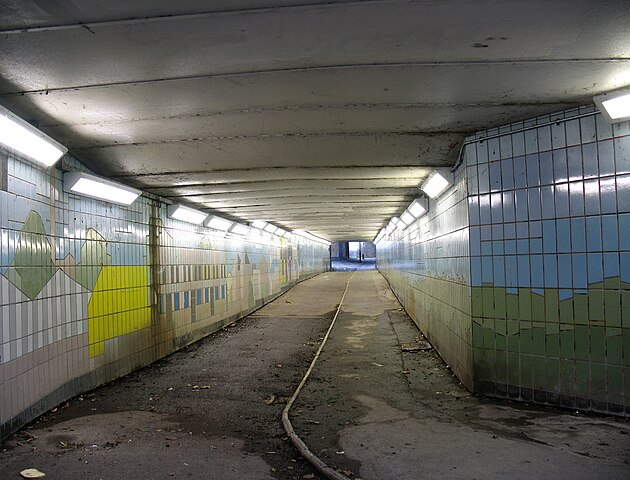
English: 15 December 2010. Subway tunnel under the main railway line. It links the east end of Park View Road with Clendish Marsh in the Lee Valley Regional Park.
I was out with Reg Rice and Lorna Reith - my fellow Tottenham Hale ward councillors. We walked round with Brian Ellick and Noshaba Shah from Haringey's Street Enforcement team. In the past there were problems with the damaged lights and water leaks in the subway. Where is this subway? Please see the dotted yellow line in the first Google aerial photo below. There's also a footbridge across the railway - shown by the red line. A path continues under Watermead Way - the north-south road, elevated on this section to cross the railway. On the second (larger scale) aerial photo below I've drawn both of these as a single short red line across the railway and road. Also in that photo I've used bright green to show the approximate position of the proposed Green Link - a footway which would slice across the southern end of Down Lane Park. As you can see from my own photos and Google's, there is a need to improve access for Tottenham residents to the River Lee and the Regional Park. But the Green Link is not designed for this purpose. It would run approximately 70 metres north of Hale Road - the existing route to Tottenham Hale station. In my personal view, the central purpose of the Green Link is to provide a public subsidy which benefits the developers of Hale Village. I commented here about the scheme. Even at the best of times it would be wasteful and unnecessary. At a time of horrendous cuts imposed by the Coalition Government, such plans need dumping in the garbage - and with no future recycling. As long as public bodies focus their major effort and resources on the "Hale Village" development, there will be no significant improvement in access by Tottenham residents to the Lee Valley Park. On the contrary, the slabs and canyons of Hale Village - and perhaps of Hale Wharf in a few years time - will make this part of the river far less attractive. |
| Date | |
| Source | https://www.flickr.com/photos/53921762@N00/5269414521/ |
| Author | Alan Stanton |
| Camera location | | View this and other nearby images on: OpenStreetMap |
|---|
Licensing
[edit]
- You are free:
- to share – to copy, distribute and transmit the work
- to remix – to adapt the work
- Under the following conditions:
- attribution – You must give appropriate credit, provide a link to the license, and indicate if changes were made. You may do so in any reasonable manner, but not in any way that suggests the licensor endorses you or your use.
- share alike – If you remix, transform, or build upon the material, you must distribute your contributions under the same or compatible license as the original.
| This image was originally posted to Flickr by Alan Stanton at https://flickr.com/photos/53921762@N00/5269414521. It was reviewed on 23 December 2021 by FlickreviewR 2 and was confirmed to be licensed under the terms of the cc-by-sa-2.0. |
File history
Click on a date/time to view the file as it appeared at that time.
| Date/Time | Thumbnail | Dimensions | User | Comment | |
|---|---|---|---|---|---|
| current | 09:57, 23 December 2021 | | 2,479 × 1,888 (818 KB) | Oxyman (talk | contribs) | Uploaded a work by Alan Stanton from https://www.flickr.com/photos/53921762@N00/5269414521/ with UploadWizard |
You cannot overwrite this file.
File usage on Commons
There are no pages that use this file.