File:Tuareg area ru.png
Jump to navigation
Jump to search
No higher resolution available.
Tuareg_area_ru.png (400 × 395 pixels, file size: 11 KB, MIME type: image/png)
Captions
Captions
Add a one-line explanation of what this file represents

|
This linguistic map image could be re-created using vector graphics as an SVG file. This has several advantages; see Commons:Media for cleanup for more information. If an SVG form of this image is available, please upload it and afterwards replace this template with
{{vector version available|new image name}}.
It is recommended to name the SVG file “Tuareg area ru.svg”—then the template Vector version available (or Vva) does not need the new image name parameter. |
Summary
[edit]| Description |
|
||
| Date | |||
| Source |
|
||
| Author | Mark Dingemanse | ||
| Permission (Reusing this file) |
This file is licensed under the Creative Commons Attribution 2.5 Generic license.
|
||
| Other versions |
[]
|


File history
Click on a date/time to view the file as it appeared at that time.
| Date/Time | Thumbnail | Dimensions | User | Comment | |
|---|---|---|---|---|---|
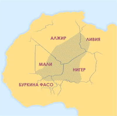
| current | 11:10, 8 January 2008 | | 400 × 395 (11 KB) | Chesnok (talk | contribs) | Areas where significant numbers of Tuaregs live. (Map with Russian labels.) ==Sources used to draw this map== *Basset (1952) *Bernus (1996) ''Touaregs: un peuple du désert''. *Lhote (1984) *Sudlow (2001) *Bougchiche, Lamara. (1997) ''Langues et litterat |
You cannot overwrite this file.
File usage on Commons
The following 7 pages use this file:
File usage on other wikis
The following other wikis use this file:
- Usage on ru.wikipedia.org
- Usage on ru.wikinews.org
- Usage on sr.wikinews.org
- Usage on uk.wikipedia.org