File:Tsuga canadensis range map 2.png
Jump to navigation
Jump to search

Size of this preview: 799 × 599 pixels. Other resolutions: 320 × 240 pixels | 640 × 480 pixels | 1,024 × 768 pixels | 1,280 × 960 pixels | 2,560 × 1,920 pixels | 6,736 × 5,053 pixels.
Original file (6,736 × 5,053 pixels, file size: 539 KB, MIME type: image/png)
Captions
Captions
Add a one-line explanation of what this file represents
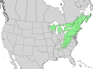
| Description | Range map of eastern hemlock (Tsuga canadensis) | |||
| Date | ||||
| Source | Digital representation of "Atlas of United States Trees" by Elbert L. Little, Jr. [1] | |||
| Author | U.S. Geological Survey | |||
| Permission (Reusing this file) |
|
File history
Click on a date/time to view the file as it appeared at that time.
| Date/Time | Thumbnail | Dimensions | User | Comment | |
|---|---|---|---|---|---|
| current | 23:40, 5 January 2014 | | 6,736 × 5,053 (539 KB) | Nonenmac (talk | contribs) | No striping noise. Added province borders. Higher resolution. Colored to match most taxoboxes. |
| 12:21, 8 December 2010 |  | 1,200 × 900 (214 KB) | Iifar (talk | contribs) | {{Information |Description=Range map of eastern hemlock (''Tsuga canadensis'') |Source=Digital representation of "Atlas of United States Trees" by Elbert L. Little, Jr. [http://esp.cr.usgs.gov/data/atlas/little/] |Date=1999 |Author=U.S. Geological Survey |
You cannot overwrite this file.
File usage on Commons
The following 4 pages use this file:
File usage on other wikis
The following other wikis use this file:
- Usage on be.wikipedia.org
- Usage on en.wikipedia.org
- Usage on et.wikipedia.org
- Usage on fr.wikipedia.org
- Usage on no.wikipedia.org
- Usage on pl.wikipedia.org
- Usage on ru.wikipedia.org