File:Trzcianka (gmina) location map.png
Jump to navigation
Jump to search

Size of this preview: 800 × 551 pixels. Other resolutions: 320 × 220 pixels | 640 × 441 pixels | 1,024 × 706 pixels | 1,434 × 988 pixels.
Original file (1,434 × 988 pixels, file size: 112 KB, MIME type: image/png)
Captions
Captions
Add a one-line explanation of what this file represents
| Description |
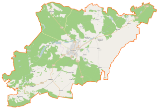
Polski: Mapa gminy Trzcianka, Polska
English: Map of Gmina Trzcianka, Poland |
|||||||||
| Date | ||||||||||
| Source | You may find a page on the OpenStreetMap wiki page for Trzcianka (gmina) | |||||||||
| Creator |
OpenStreetMap contributors OpenStreetMap contributors |
|||||||||
| Permission (Reusing this file) |
OpenStreetMap data is available under the Open Database License (details). Map tiles are licensed under the Creative Commons Attribution-ShareAlike 2.0 license (CC-BY-SA 2.0).
This file is licensed under the Creative Commons Attribution-Share Alike 2.0 Generic license.
|
|||||||||
| Geotemporal data | ||||||||||
| Bounding box |
|
|||||||||
| Georeferencing | If inappropriate please set warp_status = skip to hide. | |||||||||
File history
Click on a date/time to view the file as it appeared at that time.
| Date/Time | Thumbnail | Dimensions | User | Comment | |
|---|---|---|---|---|---|
| current | 09:51, 1 December 2014 | | 1,434 × 988 (112 KB) | VanWiel (talk | contribs) | |
| 06:47, 26 November 2014 |  | 1,434 × 988 (138 KB) | VanWiel (talk | contribs) | {{OpenStreetMap | name = Trzcianka (gmina) | location = Trzcianka (gmina) | description = {{pl|Mapa gminy Trzcianka, Polska}} {{en|Map of Gmina Trzcianka, Poland}} | top = 53.1356 | bottom = 52.9319... |
You cannot overwrite this file.
File usage on Commons
There are no pages that use this file.
File usage on other wikis
The following other wikis use this file:
- Usage on fr.wikipedia.org
- Usage on nl.wikipedia.org
- Usage on pl.wikipedia.org
- Trzcianka
- Trzcianka (gmina)
- Biernatowo
- Niekursko (wieś w województwie wielkopolskim)
- Radolin (województwo wielkopolskie)
- Sarcz
- Straduń
- Wapniarnia Pierwsza
- Wapniarnia Trzecia
- Górnica (województwo wielkopolskie)
- Przyłęki (województwo wielkopolskie)
- Rychlik (wieś w województwie wielkopolskim)
- Siedlisko (województwo wielkopolskie)
- Smolarnia (powiat czarnkowsko-trzcianecki)
- Teresin (wieś w województwie wielkopolskim)
- Kępa (powiat czarnkowsko-trzcianecki)
- Łomnica (wieś w powiecie czarnkowsko-trzcianeckim)
- Osiniec (powiat czarnkowsko-trzcianecki)
- Rudka (powiat czarnkowsko-trzcianecki)
- Runowo (powiat czarnkowsko-trzcianecki)
- Stobno (wieś w powiecie czarnkowsko-trzcianeckim)
- Biała (gmina Trzcianka)
- Sarcze (jezioro na Pojezierzu Wałeckim)
- Trzcianka (stacja kolejowa)
- Nowa Wieś (powiat czarnkowsko-trzcianecki)
- Pokrzywno (Kępa)
- Wrząca (powiat czarnkowsko-trzcianecki)
- Kadłubek (województwo wielkopolskie)
- Dłużewo
- Jezioro Leśne (województwo wielkopolskie)
- Łomnica-Młyn
- Łomnica-Folwark
- Przyłęg (województwo wielkopolskie)
- Kochanówka (Sarcz)
- Pańska Łaska
- Smolary (Straduń)
- Gintorowo
- Teresin-Karczma
- Ogorzałe
- Karcze (województwo wielkopolskie)
- Łomnica Pierwsza
- Długie Jezioro (Pojezierze Wałeckie)
- Moczytko (jezioro na Pojezierzu Wałeckim)
- Wygoda (jezioro na Pojezierzu Wałeckim)
- Okunie (jezioro)
- Straduń (jezioro)
- Parafia św. Jana Chrzciciela w Trzciance
- Parafia Matki Bożej Saletyńskiej w Trzciance
View more global usage of this file.
_location_map.png)
_location_map.png&oldid=607603744)