File:Trostberg, Hauptstr 57, Tafel, 1.jpeg
From Wikimedia Commons, the free media repository
Jump to navigation
Jump to search
![File:Trostberg, Hauptstr 57, Tafel, 1.jpeg](https://upload.wikimedia.org/wikipedia/commons/thumb/7/7f/Trostberg%2C_Hauptstr_57%2C_Tafel%2C_1.jpeg/800px-Trostberg%2C_Hauptstr_57%2C_Tafel%2C_1.jpeg?20180630155613)
Size of this preview: 800 × 559 pixels. Other resolutions: 320 × 224 pixels | 640 × 447 pixels | 1,024 × 716 pixels | 1,280 × 895 pixels | 2,816 × 1,968 pixels.
Original file (2,816 × 1,968 pixels, file size: 1.73 MB, MIME type: image/jpeg)
File information
Structured data
Captions
Captions
Add a one-line explanation of what this file represents
Summary
[edit]DescriptionTrostberg, Hauptstr 57, Tafel, 1.jpeg |
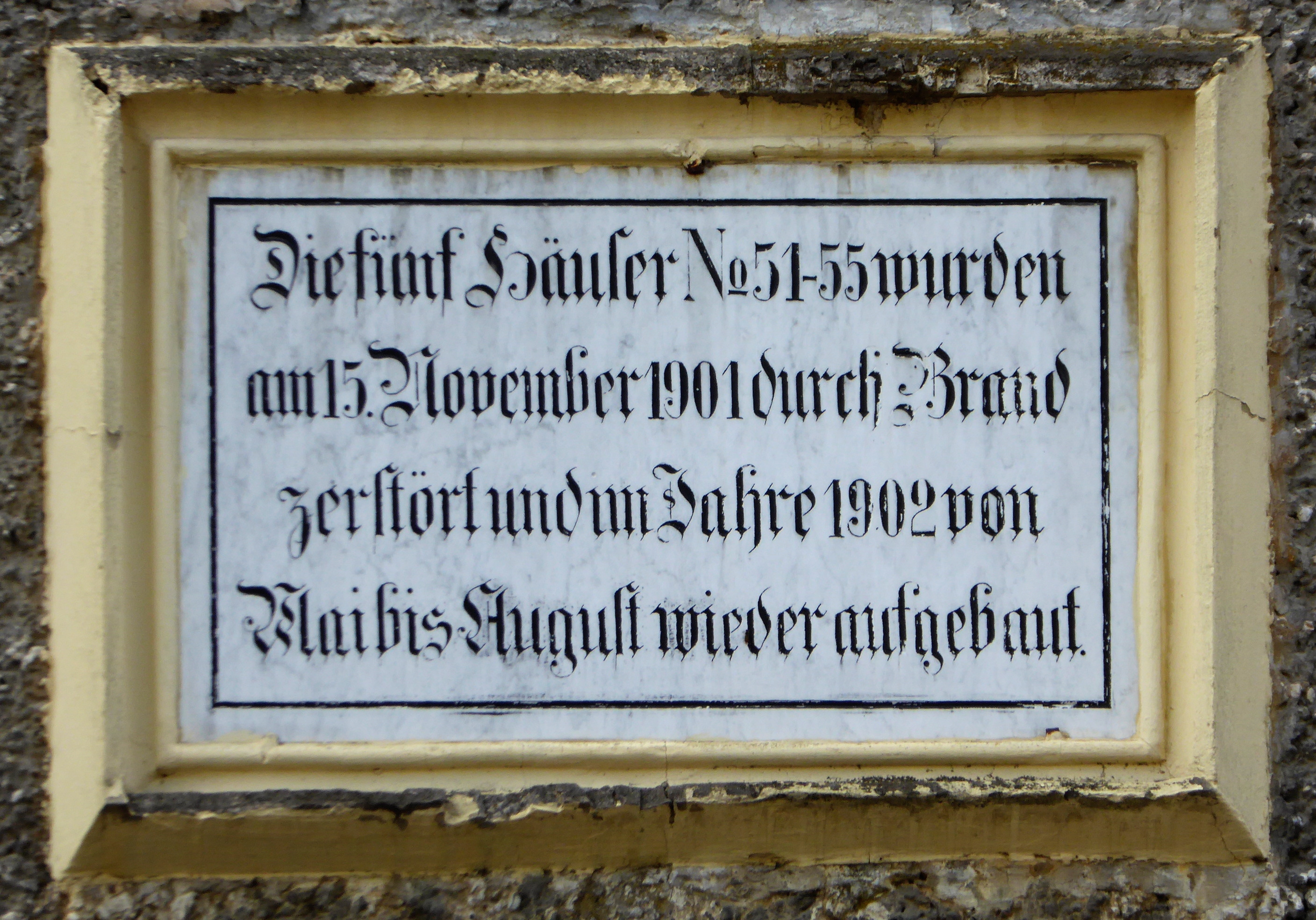
Deutsch: Trostberg, Tafel am Haus Hauptstraße 57.
Esperanto: Trostberg (DE), tabulo sur la domo Hauptstrasse 57.
„Die fünf Häuser № 51–55 wurden am 15. November 1901 durch Brand zerstört und im Jahre 1902 von Mai bis August wieder aufgebaut.“ |
||
Date | |||
Source | Self-photographed | ||
Author | Renardo la vulpo | ||
Permission (Reusing this file) |
Renardo la vulpo, the copyright holder of this work, hereby publishes it under the following license: ![]() ![]() ![]() This file is licensed under the Creative Commons Attribution-Share Alike 4.0 International license. Attribution: Renardo la vulpo
|
Camera location | 48° 01′ 46.4″ N, 12° 33′ 19.2″ E ![]() ![]() | View this and other nearby images on: OpenStreetMap | ![]() |
---|
File history
Click on a date/time to view the file as it appeared at that time.
Date/Time | Thumbnail | Dimensions | User | Comment | |
---|---|---|---|---|---|
current | 15:56, 30 June 2018 | ![]() | 2,816 × 1,968 (1.73 MB) | Renardo la vulpo (talk | contribs) | {{Information |description={{de|1=Trostberg, Tafel am Haus Hauptstraße 57.}} {{eo|1=Trostberg (DE), tabulo sur la domo ''Hauptstrasse 57''.}} {{Baudenkmal Bayern|D-1-89-157-38}} „Die Häuser № 51–55 wurden am 15. November 1901 durch Brand zerstört und im Jahre 1902 von Mai bis August wieder aufgebaut.“ |date= 2018-06-22 |source= {{self-photographed}} |author= {{U|Renardo la vulpo}} |permission= {{self|a... |
You cannot overwrite this file.
File usage on Commons
The following page uses this file:
Metadata
This file contains additional information such as Exif metadata which may have been added by the digital camera, scanner, or software program used to create or digitize it. If the file has been modified from its original state, some details such as the timestamp may not fully reflect those of the original file. The timestamp is only as accurate as the clock in the camera, and it may be completely wrong.
Camera manufacturer | Panasonic |
---|---|
Camera model | DMC-TZ61 |
Exposure time | 1/160 sec (0.00625) |
F-number | f/5.6 |
ISO speed rating | 100 |
Date and time of data generation | 14:05, 22 June 2018 |
Lens focal length | 47.5 mm |
Latitude | 48° 1′ 46.8″ N |
Longitude | 12° 33′ 19.72″ E |
Orientation | Normal |
Horizontal resolution | 180 dpi |
Vertical resolution | 180 dpi |
Software used | GIMP 2.8.22 |
File change date and time | 12:43, 30 June 2018 |
Y and C positioning | Co-sited |
Exposure Program | Normal program |
Exif version | 2.3 |
Date and time of digitizing | 14:05, 22 June 2018 |
Meaning of each component |
|
Image compression mode | 4 |
APEX exposure bias | 0 |
Maximum land aperture | 4.96875 APEX (f/5.6) |
Metering mode | Center weighted average |
Light source | Unknown |
Flash | Flash did not fire, compulsory flash suppression |
Supported Flashpix version | 1 |
Color space | sRGB |
Sensing method | One-chip color area sensor |
File source | Digital still camera |
Scene type | A directly photographed image |
Custom image processing | Normal process |
Exposure mode | Auto exposure |
White balance | Auto white balance |
Digital zoom ratio | 0 |
Focal length in 35 mm film | 265 mm |
Scene capture type | Standard |
Scene control | None |
Contrast | Normal |
Saturation | Normal |
Sharpness | Normal |
GPS time (atomic clock) | 12:05 |
Receiver status | Measurement in progress |
Measurement mode | 2-dimensional measurement |
Measurement precision | Fair (1.4) |
Geodetic survey data used | WGS-84 |
Name of GPS area | Trostberg |
GPS date | 22 June 2018 |
GPS tag version | 0.0.3.2 |
Image width | 3,264 px |
Image height | 2,448 px |
Name of GPS processing method | 14 bytes undefined data |