File:Tropical Storm Dorian (MODIS 2019-08-29).jpg

Original file (3,950 × 3,258 pixels, file size: 1.28 MB, MIME type: image/jpeg)
Captions
Captions
Summary
[edit].jpg&action=edit§ion=1)
| Description |
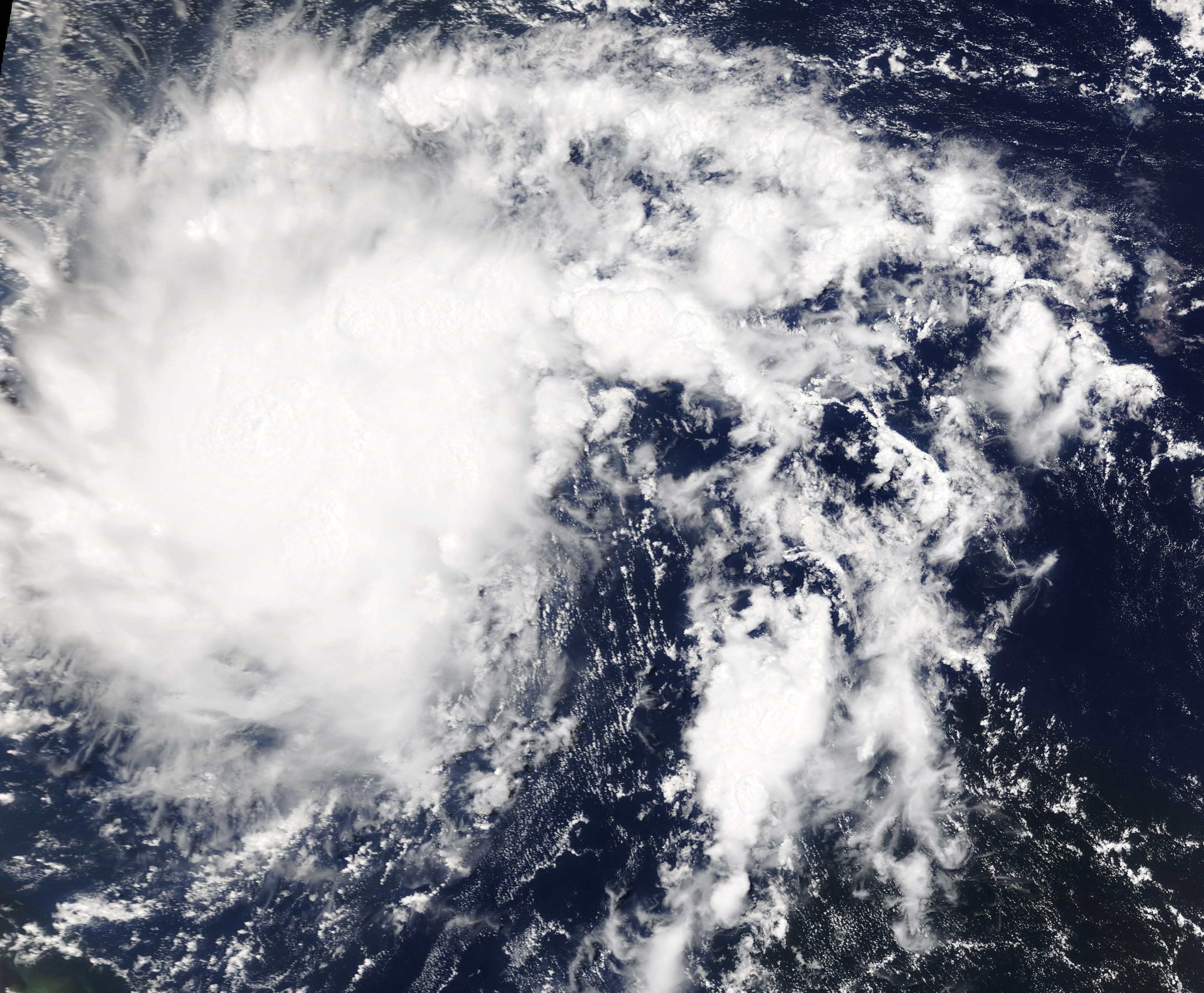
English: Hurricane Dorian formed as a tropical depression on Saturday, August 24 about 805 miles (1,300 km) east-southeast of Barbados. By 5 p.m. EDT that day, the depression strengthened into a tropical storm and was named Dorian. By that evening, Tropical Storm Dorian was moving toward the west near 14 mph (22 km/h), tracking towards the Leeward Islands, Puerto Rico, Virgin Islands, and the Southeastern United States. By the evening of August 24 the storm was carrying maximum sustained winds near 40 mph (65 km/h), with higher gusts.
Dorian continued to strengthen and on August 27, Dorian moved across St. Lucia and into the eastern Caribbean Sea bringing tropical-storm-force winds with it. The National Hurricane Center (NHC) said the Caribbean composite radar data showed that Dorian was a very compact system and that it still lacked a well-defined inner core. On August 28, the National Emergency Management Organization (NEMO) reported that St. Lucia suffered no major damage. At 2:00 p.m. EDT on August 28 the NHC reported that Dorian had become a hurricane near St. Thomas in the US Virgin Islands and that there were multiple reports of hurricane-force winds on that island. Maximum sustained winds had reached 75 mph (120 km/h). Dorian continued to strengthen as it lashed the US Virgin Islands and Puerto Rico with heavy rain and hurricane-force winds on the afternoon of August 28. By 8:00 pm that day, Hurricane Dorian was pulling away from Puerto Rico and taking aim at the Southeastern United States. The NCH reported its location at 19.2 North and 65.7 West, or about 60 miles (95 km) north-northwest of San Juan, Puerto Rico. Maximum sustained winds were 80 mph (130 km/h) and it was travelling northwest at 13 mph (20 km/h). Dorian is forecast to strengthen into a powerful hurricane during the next few days over Atlantic waters. The following rainfall totals are expected over the next several days: Northern Leeward Islands, 1-3 inches; Central and northwestern Bahamas, 2-4 in with 6 in isolated areas; and Coastal sections of the Southeastern United States, 4-8 in with isolated areas of 10 inches. On August 26, 2019, the Moderate Resolution Imaging Spectroradiometer (MODIS) on board NASA’s Terra satellite acquired a true-color image of Tropical Storm Dorian approaching the Leeward Islands. |
||
| Date | Taken on 26 August 2019 | ||
| Source |
Tropical Storm Dorian (direct link)
|
||
| Author | MODIS Land Rapid Response Team, NASA GSFC |
| This media is a product of the Terra mission Credit and attribution belongs to the mission team, if not already specified in the "author" row |
Licensing
[edit].jpg&action=edit§ion=2)
| This file is in the public domain in the United States because it was solely created by NASA. NASA copyright policy states that "NASA material is not protected by copyright unless noted". (See Template:PD-USGov, NASA copyright policy page or JPL Image Use Policy.) | ||
 |
Warnings:
|
File history
Click on a date/time to view the file as it appeared at that time.
| Date/Time | Thumbnail | Dimensions | User | Comment | |
|---|---|---|---|---|---|
| current | 03:05, 17 February 2024 | | 3,950 × 3,258 (1.28 MB) | OptimusPrimeBot (talk | contribs) | #Spacemedia - Upload of http://modis.gsfc.nasa.gov/gallery/images/image08292019_250m.jpg via Commons:Spacemedia |
You cannot overwrite this file.
File usage on Commons
There are no pages that use this file.
.jpg&oldid=909381020)