File:Tropical Cyclone Nisarga (MODIS 2020-06-04).jpg

Original file (5,444 × 4,551 pixels, file size: 2.54 MB, MIME type: image/jpeg)
Captions
Captions
Summary
[edit].jpg&action=edit§ion=1)
| Description |
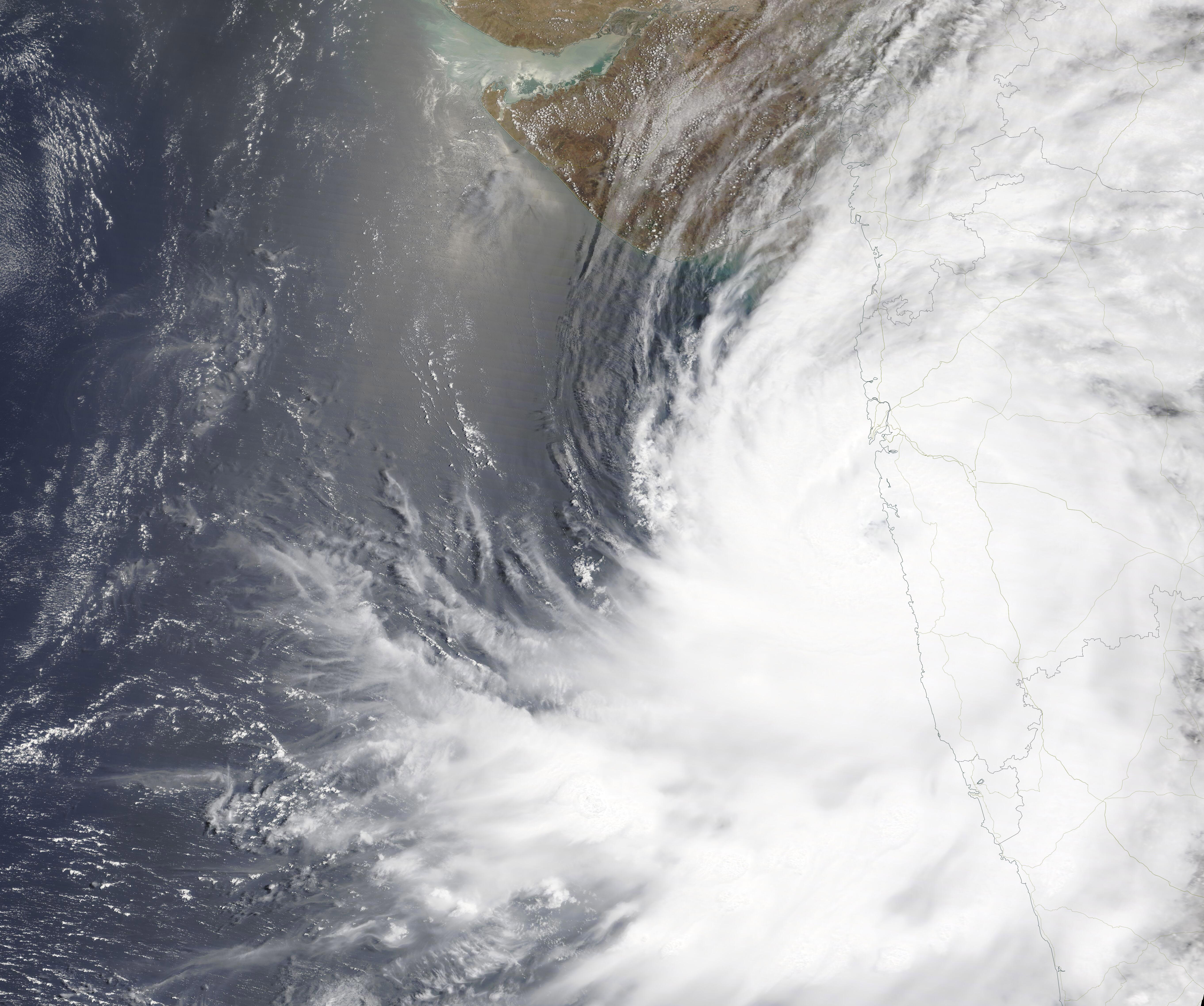
English: A short-lived tropical cyclone slammed into the coast of India near Mumbai on June 3, 2020, bringing heavy rains and strong winds to the region. Tropical Cyclone Nisarga is a record-setter. An article by AccuWeather quoted Lead International Meteorologist Jason Nicholls as saying, “Prior to Nisarga, there had been no cyclonic storms that struck Mumbai/Bombay during the pre-monsoon period (May-June)”. Only three cyclonic storms have ever made landfall over or near Mumbai since 1891, and all three were in October or November.
Nisarga formed around 5:00 p.m. EDT (2100 UTC) on June 2, and at that time sported maximum sustained winds near 46 mph (74 km/h). Within 12 hours, the storm intensified to hurricane strength. According to the Joint Typhoon Warning Center, Tropical Cyclone Nisarga made landfall at about 4:00 am EDT (0800 UTC) June 3 carrying maximum sustained winds of about 86.3 mph (139 km/h). According to the India Meteorological Department (IMD), winds of 102 km/h (63 mph) were reported in Alibagh, just north of the landfall position on June 3. At 11:00 am EDT (1500 UTC) on June 3, the Joint Typhoon Warning Center issued its final advisory on Nisarga. At that time, the storm’s maximum sustained winds were 74.8 mph (120 km/h), or a minimal Category 1 storm on the Saffir Simpson Hurricane Wind Scale. The storm was quickly weakening as it moved inland and was expected to dissipate within 24 hours. On June 3, 2020, the Moderate Resolution Imaging Spectroradiometer (MODIS) on board NASA’s Terra satellite acquired a stunning true-color image of Tropical Cyclone Nisarga close to the time of landfall over western India. Convective bands wrapped into a cloud-filled center as that center crossed the coast near Mumbai. |
||
| Date | Taken on 3 June 2020 | ||
| Source |
Tropical Cyclone Nisarga (direct link)
|
||
| Author | MODIS Land Rapid Response Team, NASA GSFC |
| This media is a product of the Terra mission Credit and attribution belongs to the mission team, if not already specified in the "author" row |
Licensing
[edit].jpg&action=edit§ion=2)
| This file is in the public domain in the United States because it was solely created by NASA. NASA copyright policy states that "NASA material is not protected by copyright unless noted". (See Template:PD-USGov, NASA copyright policy page or JPL Image Use Policy.) | ||
 |
Warnings:
|
File history
Click on a date/time to view the file as it appeared at that time.
| Date/Time | Thumbnail | Dimensions | User | Comment | |
|---|---|---|---|---|---|
| current | 03:04, 17 February 2024 | | 5,444 × 4,551 (2.54 MB) | OptimusPrimeBot (talk | contribs) | #Spacemedia - Upload of http://modis.gsfc.nasa.gov/gallery/images/image06042020_250m.jpg via Commons:Spacemedia |
You cannot overwrite this file.
File usage on Commons
There are no pages that use this file.
.jpg&oldid=852932463)