File:Trolley for goods.jpg
Jump to navigation
Jump to search

Size of this preview: 800 × 450 pixels. Other resolutions: 320 × 180 pixels | 640 × 360 pixels | 1,024 × 576 pixels | 1,280 × 720 pixels | 3,072 × 1,728 pixels.
Original file (3,072 × 1,728 pixels, file size: 1.27 MB, MIME type: image/jpeg)
Captions
Captions
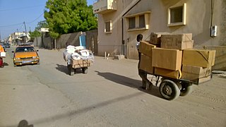
trolley that can transport heavy goods or goods in quantity.
Summary
[edit]
| Description |
English: It is a mode of transport used frequently in markets, stations, road stations etc. In Senegal, precisely in public spaces, we find this kind of transport of goods. A person wishing to transport his goods from one point to another calls upon his persons to transport them the goods in order to pay for them. These people earn their lives on their carts
Français : C'est un mode de transport appliqué fréquemment dans les marchés, gares, gares routières etc. Au Sénégal, précisément aux espaces publics on y trouve ce genre de transport de marchandises. En effet une personne désirant transporter ses marchandises d'un point en un autre fait appel à ces personnes pour qu'ils leur transportent les marchandises afin de les payer. Ces personnes gagnent leur vie via leurs chariots
中文:这是一种在市场,车站,公路站等地方经常使用的运输方式。在塞内加尔,正是在公共场所,这种类型的货物运输就是这样。 希望将货物从一个地点运输到另一地点的人要求这些人运输货物,以便支付货款。 这些人在手推车上谋生
Español: Es un modo de transporte que se aplica con frecuencia en los mercados, estaciones de tren, estaciones de carretera, etc. En Senegal, precisamente en los espacios públicos se encuentra este tipo de transporte de mercancías. En efecto, una persona que desee transportar sus mercancías de un punto a otro recurre a esas personas para que les transporten las mercancías a fin de pagarlas. Estas personas se ganan la vida con sus carretas
Deutsch: Es handelt sich um ein Verkehrsmittel, das häufig in Märkten, Bahnhöfen, Straßenbahnhöfen usw. eingesetzt wird. Eine Person, die ihre Waren von einem Ort zum anderen befördern möchte, ruft diese Personen auf, ihnen die Waren zur Bezahlung zu bringen. Diese Menschen verdienen ihren Lebensunterhalt mit ihren Einkaufswagen
|
||
| Date | |||
| Source | Own work | ||
| Author | Babacar Dioum |
| Camera location | | View this and other nearby images on: OpenStreetMap |
|---|
Licensing
[edit]
I, the copyright holder of this work, hereby publish it under the following license:
This file is licensed under the Creative Commons Attribution-Share Alike 4.0 International license.
- You are free:
- to share – to copy, distribute and transmit the work
- to remix – to adapt the work
- Under the following conditions:
- attribution – You must give appropriate credit, provide a link to the license, and indicate if changes were made. You may do so in any reasonable manner, but not in any way that suggests the licensor endorses you or your use.
- share alike – If you remix, transform, or build upon the material, you must distribute your contributions under the same or compatible license as the original.

|
This image was uploaded as part of Wiki Loves Africa 2020 photographic contest.
|
File history
Click on a date/time to view the file as it appeared at that time.
| Date/Time | Thumbnail | Dimensions | User | Comment | |
|---|---|---|---|---|---|
| current | 16:28, 8 April 2020 | | 3,072 × 1,728 (1.27 MB) | Babacar Dioum (talk | contribs) | Uploaded own work with UploadWizard |
You cannot overwrite this file.
File usage on Commons
There are no pages that use this file.