File:Trolley-zuerich.png
From Wikimedia Commons, the free media repository
Jump to navigation
Jump to search

Size of this preview: 676 × 599 pixels. Other resolutions: 271 × 240 pixels | 541 × 480 pixels | 866 × 768 pixels | 1,155 × 1,024 pixels | 1,810 × 1,605 pixels.
Original file (1,810 × 1,605 pixels, file size: 451 KB, MIME type: image/png)
File information
Structured data
Captions
Captions
Add a one-line explanation of what this file represents
Summary
[edit]| DescriptionTrolley-zuerich.png |
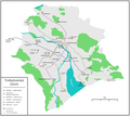
English: Map of the Zürich trolleybus system
Deutsch: Karte des Trolleybusnetzes Zürich |
| Date | |
| Source |
Own work Map was created using:
|
| Author | Pechristener |
| Permission (Reusing this file) |
Map data (c) OpenStreetMap (and) contributors, CC-BY-SA |
Licensing
[edit]This file is licensed under the Creative Commons Attribution-Share Alike 2.0 Generic license.
- You are free:
- to share – to copy, distribute and transmit the work
- to remix – to adapt the work
- Under the following conditions:
- attribution – You must give appropriate credit, provide a link to the license, and indicate if changes were made. You may do so in any reasonable manner, but not in any way that suggests the licensor endorses you or your use.
- share alike – If you remix, transform, or build upon the material, you must distribute your contributions under the same or compatible license as the original.
File history
Click on a date/time to view the file as it appeared at that time.
| Date/Time | Thumbnail | Dimensions | User | Comment | |
|---|---|---|---|---|---|
| current | 14:01, 26 February 2012 |  | 1,810 × 1,605 (451 KB) | Pechristener (talk | contribs) | fix in Legende |
| 23:02, 18 February 2012 |  | 1,810 × 1,605 (443 KB) | Pechristener (talk | contribs) | 33 und 46 geflickt / Verlauf der Sihl korigiert / Haltestellen am HB korigiert | |
| 23:51, 11 February 2012 |  | 1,824 × 1,621 (409 KB) | Pechristener (talk | contribs) | Halbgeviertstriche | |
| 13:59, 11 February 2012 |  | 1,824 × 1,622 (409 KB) | Pechristener (talk | contribs) | Fehler bei der Lineinführung der 34 behoben. | |
| 04:21, 11 February 2012 |  | 1,824 × 1,621 (410 KB) | Pechristener (talk | contribs) | Bahnhof Schlieren -> Schlieren Zentrum / Zentralwerkstatt hinzu / Betriebsstrecke Schulhausstrasse / Garage Hardau / Betriebsstrecke Hohlstrasse / Eisnpurstrecken 33 und 72 ergänzt | |
| 13:05, 9 February 2012 |  | 1,824 × 1,620 (404 KB) | Pechristener (talk | contribs) | korr Albisriederplatz, Zwischenwendeschleifen hinzu, korr Busdepot | |
| 22:55, 8 February 2012 |  | 1,828 × 1,620 (395 KB) | Pechristener (talk | contribs) | * Betriebsstrcken ergänzt * Depot ergänzt * Schreibfehler "Central" korriegiert | |
| 09:47, 8 February 2012 |  | 1,832 × 1,740 (346 KB) | Pechristener (talk | contribs) | Falsche Beschriftung einer Buslinie. | |
| 09:06, 8 February 2012 |  | 1,380 × 1,296 (245 KB) | Pechristener (talk | contribs) | Fehler in der Darstellung | |
| 09:04, 8 February 2012 |  | 1,392 × 1,304 (245 KB) | Pechristener (talk | contribs) | Fehler in der Beschriftung |
You cannot overwrite this file.
File usage on Commons
The following 2 pages use this file:
File usage on other wikis
The following other wikis use this file:
- Usage on de.wikipedia.org
Metadata
This file contains additional information such as Exif metadata which may have been added by the digital camera, scanner, or software program used to create or digitize it. If the file has been modified from its original state, some details such as the timestamp may not fully reflect those of the original file. The timestamp is only as accurate as the clock in the camera, and it may be completely wrong.
| Horizontal resolution | 63.48 dpc |
|---|---|
| Vertical resolution | 63.48 dpc |
| Software used |
Hidden category: