File:Tribes of Sicily by 11th century BC.png
Jump to navigation
Jump to search
No higher resolution available.
Tribes_of_Sicily_by_11th_century_BC.png (659 × 438 pixels, file size: 29 KB, MIME type: image/png)
Captions
Captions
Add a one-line explanation of what this file represents

|
This ethnographic map image could be re-created using vector graphics as an SVG file. This has several advantages; see Commons:Media for cleanup for more information. If an SVG form of this image is available, please upload it and afterwards replace this template with
{{vector version available|new image name}}.
It is recommended to name the SVG file “Tribes of Sicily by 11th century BC.svg”—then the template Vector version available (or Vva) does not need the new image name parameter. |
Summary
[edit]| Description |
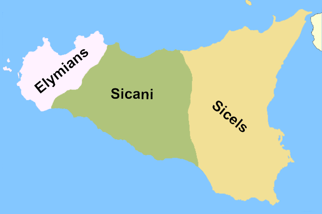
English: A rough reconstruction of the locations of the Elymians, Sicani and Sicels in Sicily around 11th century BC, before the arrival of the Phoenicians and the Greeks. Note from author: "This is a map I created which roughly depicts the location of the native Italic tribes of Sicily, no exact borders are known (as of October 2007) so this is to be taken in the context of rough areas. To devise this I have used the following informative sources[1][2][3] Version labelled in Esperanto can be reached at eo:Dosiero:Praaj triboj de Sicilio.png".
This is highly questionable. There may not even have been any "Sicels" on Sicily before the "arrival of the Phoenicians". The map is just pulled from thin air and has no relation to the 11th century. At best it shows the rough location of the three tribal groups around the 6th century.
Français : Localisation des différentes tribus en Sicile avant la colonisation grecque.
Español: Pueblos prerromanos de Sicilia: elimios (elymiī), sicanos (sicānī) y sículos (siculī). Mapa con la localización aproximada de las tribus siciliotas antes de la llegada de los griegos.
Русский: Схема расселения догреческих народов Сицилии (слева направо: элимцы, сиканы, сикулы). Схема расселения догреческих народов Сицилии (слева направо: элимцы, сиканы, сикулы). Территории племён на о. Сицилия к приходу греков. Схема расселения догреческих народов Сицилии (слева направо: элимцы, сиканы, сикулы).
Português: Os Sicanos habitavam o centro da Sicília.
Svenska: Folkslagen sikeler, elymer och sikaner: den ungefärliga utbredningen innan grekernas ankomst. Folkslagen sikeler, elymer och sikaner: den ungefärliga utbredningen innan grekernas ankomst. Folkslagen sikeler, elymer och sikaner: den ungefärliga utbredningen innan grekernas ankomst.
Català: Mapa de la situació dels sicans.
Norsk bokmål: En grovt kart over fordelingen av innfødte stammene på Sicilia i oldtiden. Et kart over Sicilia som grovt viser inndelingen av de tre folkeslagene.
Українська: Схема розселення догрецьких народів Сицилії (зліва направо: Еліми, Сікани, Сікули). Схема розселення догрецьких народів Сицилії (зліва направо: Елімці, Сікани, Сікули). Схема розселення догрецьких народів Сицилії (зліва направо: Елімці, Сікани, Сікули).
Čeština: Pravděpodobné rozmístění tří italických národů obývajících Sicílii.
Српски / srpski: Мапа положаја италских племена на Сицилији.
Lietuvių: Elymų žemės Sicilijoje. Sikanų žemės Sicilijoje.
العربية: خريطة تقريبية لانتشار الشعوب الصقلية القديمة. خريطة تقريبية لانتشار الشعوب الصقلية القديمة.
Hrvatski: Okvirna karta drevnih naroda na Siciliji. Karta položaja italskih plemena na Siciliji. Gruba karta drevnih sicilijansklih naroda. Okvirna karta drevnih naroda na Siciliji.
Eesti: Vanimad hõimud Sitsiilias.
Srpskohrvatski / српскохрватски: Okvirna karta drevnih naroda na Siciliji. Karta položaja italskih plemena na Siciliji. Gruba karta drevnih sicilijansklih naroda. Okvirna karta plemenske podjele Sicilije prije dolaska Grka.
Sicilianu: La Sicilia agghiri lu 1000 a.C. (Sicels significa Siculi nto ngrisi). |
| Date | |
| Source | Self-published work by Soprani |
| Author | Soprani |
| Other versions |
|


![[2]](http://www.conigliofamily.com/images/SicilyMap.jpg)
![[3]](https://en.wikipedia.org/wiki/Image:Sicily_elymians.png)
Licensing
[edit]
I, the copyright holder of this work, hereby publish it under the following licenses:

|
Permission is granted to copy, distribute and/or modify this document under the terms of the GNU Free Documentation License, Version 1.2 or any later version published by the Free Software Foundation; with no Invariant Sections, no Front-Cover Texts, and no Back-Cover Texts. A copy of the license is included in the section entitled GNU Free Documentation License. |
| This file is licensed under the Creative Commons Attribution-Share Alike 3.0 Unported license. | ||
| ||
| This licensing tag was added to this file as part of the GFDL licensing update. |
You may select the license of your choice.
File history
Click on a date/time to view the file as it appeared at that time.
| Date/Time | Thumbnail | Dimensions | User | Comment | |
|---|---|---|---|---|---|
| current | 18:23, 7 October 2007 | | 659 × 438 (29 KB) | Soprani~commonswiki (talk | contribs) | This is a map I created which roughly depicts the location of the native Italic tribes of Sicily, no exact borders are known (as of October 2007) so this is to be taken in the context of rough areas. To devise this I have used the following informative so |
You cannot overwrite this file.
File usage on Commons
The following 5 pages use this file:
File usage on other wikis
The following other wikis use this file:
- Usage on ar.wikipedia.org
- Usage on ast.wikipedia.org
- Usage on az.wikipedia.org
- Usage on cs.wikipedia.org
- Usage on de.wikipedia.org
- Usage on en.wikipedia.org
- Usage on et.wikipedia.org
- Usage on fr.wikipedia.org
- Usage on hr.wikipedia.org
- Usage on hy.wikipedia.org
- Usage on ja.wikipedia.org
- Usage on lt.wikipedia.org
- Usage on nl.wikipedia.org
- Usage on no.wikipedia.org
- Usage on pl.wikipedia.org
- Usage on scn.wikipedia.org
- Usage on sh.wikipedia.org
- Usage on simple.wikipedia.org
- Usage on sr.wikipedia.org
- Usage on sv.wikipedia.org
- Usage on uk.wikipedia.org
- Usage on www.wikidata.org
- Usage on zh.wikipedia.org