File:Trianon Karte Dt verbessert.PNG
Jump to navigation
Jump to search
No higher resolution available.
Trianon_Karte_Dt_verbessert.PNG (651 × 497 pixels, file size: 47 KB, MIME type: image/png)
Captions
Captions
Add a one-line explanation of what this file represents
Summary
[edit]
| Description |
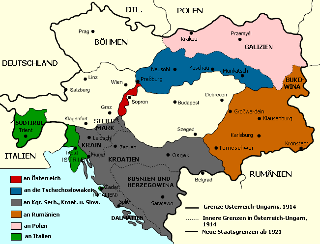
Deutsch: Trianon-Karte, mit den Gebietsverlusten Österreich-Ungarns, und den neuen Staatsgrenzen in Mittel- und Osteuropa ab 1920/1921. |
| Date | 4 February 2007 (original upload date) |
| Source | Überarbeitung von :hu:Kép:Trianon.png |
| Author | Christo, Xbspiro, Imre |
Licensing
[edit]
This file is licensed under the Creative Commons Attribution 2.5 Generic license.
- You are free:
- to share – to copy, distribute and transmit the work
- to remix – to adapt the work
- Under the following conditions:
- attribution – You must give appropriate credit, provide a link to the license, and indicate if changes were made. You may do so in any reasonable manner, but not in any way that suggests the licensor endorses you or your use.

|
Permission is granted to copy, distribute and/or modify this document under the terms of the GNU Free Documentation License, Version 1.2 or any later version published by the Free Software Foundation; with no Invariant Sections, no Front-Cover Texts, and no Back-Cover Texts. A copy of the license is included in the section entitled GNU Free Documentation License. |
| This file is licensed under the Creative Commons Attribution-Share Alike 3.0 Unported license. | ||
| ||
| This licensing tag was added to this file as part of the GFDL licensing update. |
Original upload log
[edit]
The original description page was here. All following user names refer to de.wikipedia.
| Date/Time | Dimensions | User | Comment |
|---|---|---|---|
| 2007-02-04 15:55 | 655×500× (47151 bytes) | Imre | Trianon-Karte, mit den Gebietsverlusten Österreich-Ungarns, und den neuen Staatsgrenzen in Mittel- und Osteuropa ab 1920/1921. |
File history
Click on a date/time to view the file as it appeared at that time.
| Date/Time | Thumbnail | Dimensions | User | Comment | |
|---|---|---|---|---|---|
| current | 16:34, 16 March 2020 | | 651 × 497 (47 KB) | Ras67 (talk | contribs) | black frame removed |
| 19:47, 8 April 2015 |  | 655 × 500 (46 KB) | Luke081515 (talk | contribs) | Transferred from de.wikipedia |
You cannot overwrite this file.
File usage on Commons
The following 3 pages use this file:
File usage on other wikis
The following other wikis use this file:
- Usage on de.wikipedia.org