File:Trebic karlovo namesti cerny dum trapp.jpg
Jump to navigation
Jump to search

Size of this preview: 505 × 599 pixels. Other resolutions: 202 × 240 pixels | 404 × 480 pixels | 647 × 768 pixels | 1,221 × 1,449 pixels.
Original file (1,221 × 1,449 pixels, file size: 633 KB, MIME type: image/jpeg)
Captions
Captions
Add a one-line explanation of what this file represents
Summary
[edit]| Description |
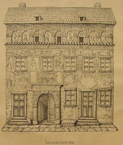
Čeština: Třebíč. Karlovo náměstí. Černý dům. 49°12′59.00″N 15°52′52.00″E
English: Třebíč. Charles Square. Black House |
| Date | |
| Source | Památky archaeologické a a místopisné - II díl, 1857 |
| Author | Mořic Vilém Trapp (1825–1895) |
| Other versions |
| Camera location | | View this and other nearby images on: OpenStreetMap |
|---|
Licensing
[edit]
|
This work is in the public domain in its country of origin and other countries and areas where the copyright term is the author's life plus 70 years or fewer. | |
| This file has been identified as being free of known restrictions under copyright law, including all related and neighboring rights. | |
File history
Click on a date/time to view the file as it appeared at that time.
| Date/Time | Thumbnail | Dimensions | User | Comment | |
|---|---|---|---|---|---|
| current | 14:18, 25 October 2007 | | 1,221 × 1,449 (633 KB) | Nostrifikator (talk | contribs) | {{Information |Description= {{cs|Třebíč. Karlovo náměstí. Černý dům. 49°12′59.00″N 15°52′52.00″E}} {{en|Třebíč. Charles Square. Black House}} |Source=Památky archeologické, 1857 |Date=2006-01-18 |Author=Mořic Vilém Trapp (1825– |
You cannot overwrite this file.
File usage on Commons
The following page uses this file:
File usage on other wikis
The following other wikis use this file:
- Usage on cs.wikipedia.org