File:Trawling-footprint-region (OWID 1134).png
Jump to navigation
Jump to search
Size of this preview: 800 × 565 pixels. Other resolutions: 320 × 226 pixels | 640 × 452 pixels.
Original file (850 × 600 pixels, file size: 102 KB, MIME type: image/png)
Captions
Captions
Add a one-line explanation of what this file represents
Summary
[edit].png&action=edit§ion=1)
| Trawling footprint region | |
|---|---|
| Title |
Trawling footprint region |
| Description |
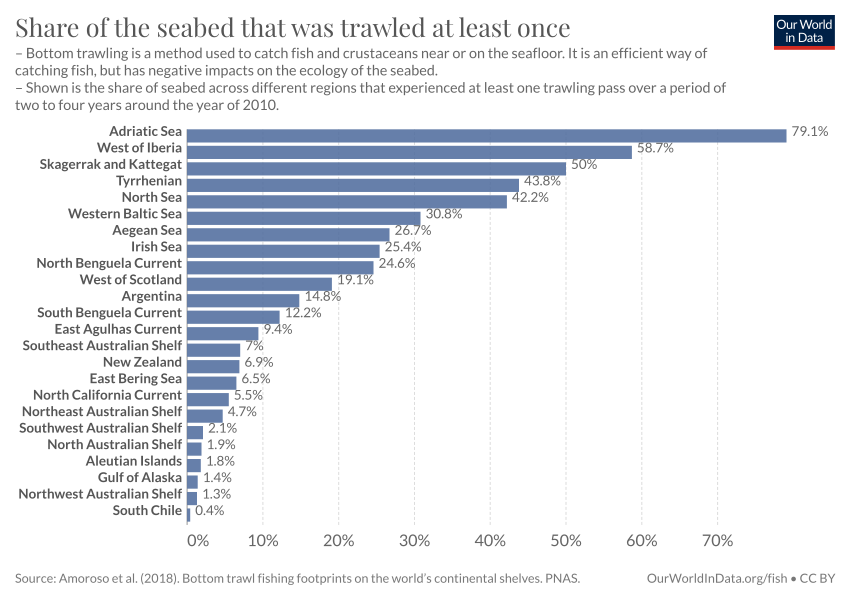
Share of the seabed that was trawled at least once. Bottom trawling is a method used to catch fish and crustaceans near or on the seafloor. It is an efficient way of catching fish, but has negative impacts on the ecology of the seabed. |
| Credit line | Our World in Data |
| References | Amoroso et al. (2018). Bottom trawl fishing footprints on the world’s continental shelves. PNAS. |
| Source | https://OurWorldinData.org/fish |
| Permission (Reusing this file) |
Our World in Data openly licence all text and visualisations on their website. |
Licensing
[edit].png&action=edit§ion=2)
This file is licensed under the Creative Commons Attribution 4.0 International license.
- You are free:
- to share – to copy, distribute and transmit the work
- to remix – to adapt the work
- Under the following conditions:
- attribution – You must give appropriate credit, provide a link to the license, and indicate if changes were made. You may do so in any reasonable manner, but not in any way that suggests the licensor endorses you or your use.
File history
Click on a date/time to view the file as it appeared at that time.
| Date/Time | Thumbnail | Dimensions | User | Comment | |
|---|---|---|---|---|---|
| current | 19:04, 14 July 2023 | | 850 × 600 (102 KB) | Jason.nlw (talk | contribs) | pattypan 22.03 |
You cannot overwrite this file.
File usage on Commons
The following page uses this file:
.png)
.png&oldid=878152364)