File:Tranchet Axehead. (FindID 816853).jpg
Jump to navigation
Jump to search

Size of this preview: 404 × 600 pixels. Other resolutions: 162 × 240 pixels | 323 × 480 pixels | 517 × 768 pixels | 690 × 1,024 pixels | 1,379 × 2,048 pixels | 4,693 × 6,967 pixels.
Original file (4,693 × 6,967 pixels, file size: 10.61 MB, MIME type: image/jpeg)
Captions
Captions
Add a one-line explanation of what this file represents
Summary
[edit].jpg&action=edit§ion=1)
| Tranchet Axehead. | |||
|---|---|---|---|
| Photographer |
The Portable Antiquities Scheme, Lucy Bevan, 2016-11-28 11:54:57 |
||
| Title |
Tranchet Axehead. |
||
| Description |
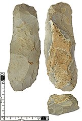
English: A tranchet axe with an irregular, variable cross-section, made on a naturally fractured, weathered nodule of mottled opaque pale grey flint. The piece is crudely bifacially flaked, one face retains a substantial area of thick weathered cortex, the other is flaked all over. The sharp cutting edge is formed by oblique removal of a small 'tranchet' flake. Unusually, the butt end is also sharp and may have been reworked to form an alternative cutting edge, also by oblique flake removals on both faces.
The margins are irregular and show evidence of deliberate battering to blunt them. The exposed surfaces are pale grey and high gloss to mid gloss patina, except on one face where off-white recortication of the naturally fractured surface is evident. Date: Late Mesolithic. Dimensions: 168mm x 57.6mm x 38.5mm. Weight: 420g. |
||
| Depicted place | (County of findspot) Dorset | ||
| Date | between 7000 BC and 4000 BC | ||
| Accession number |
FindID: 816853 Old ref: DOR-C129AA Filename: DORC129AA.jpg |
||
| Credit line |
|
||
| Source |
https://finds.org.uk/database/ajax/download/id/592142 Catalog: https://finds.org.uk/database/images/image/id/592142/recordtype/artefacts Artefact: https://finds.org.uk/database/artefacts/record/id/816853 |
||
| Permission (Reusing this file) |
Attribution License | ||
| Object location | | View this and other nearby images on: OpenStreetMap |
|---|
.jpg¶ms=050.827600_N_-002.111000_E_globe:Earth_class:object_type:object__&language=en)
Licensing
[edit].jpg&action=edit§ion=2)
This file is licensed under the Creative Commons Attribution 2.0 Generic license.
Attribution: The Portable Antiquities Scheme
- You are free:
- to share – to copy, distribute and transmit the work
- to remix – to adapt the work
- Under the following conditions:
- attribution – You must give appropriate credit, provide a link to the license, and indicate if changes were made. You may do so in any reasonable manner, but not in any way that suggests the licensor endorses you or your use.
File history
Click on a date/time to view the file as it appeared at that time.
| Date/Time | Thumbnail | Dimensions | User | Comment | |
|---|---|---|---|---|---|
| current | 02:04, 20 December 2018 | | 4,693 × 6,967 (10.61 MB) | Fæ (talk | contribs) | Portable Antiquities Scheme, DOR, FindID: 816853, mesolithic, page 2783, batch count 5916 |
You cannot overwrite this file.
File usage on Commons
The following page uses this file:
.jpg)
.jpg&oldid=742057732)