File:Tramway Bordeaux LigneB.svg
Jump to navigation
Jump to search

Size of this PNG preview of this SVG file: 512 × 362 pixels. Other resolutions: 320 × 226 pixels | 640 × 453 pixels | 1,024 × 724 pixels | 1,280 × 905 pixels | 2,560 × 1,810 pixels.
Original file (SVG file, nominally 512 × 362 pixels, file size: 19.16 MB)
Captions
Captions
Add a one-line explanation of what this file represents
Summary
[edit]
| Description |
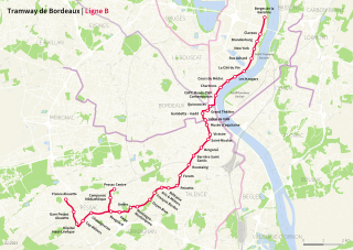
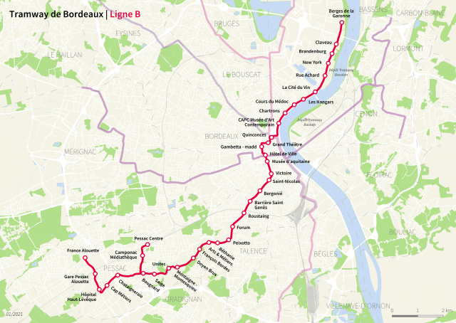
English: Map of the line B of the tram network of Bordeaux
Français : Plan de la ligne B du tramway de Bordeaux
Deutsch: Plan der Linie B der Straßenbahn Bordeaux |
| Date | |
| Source | base data and background: Open Data Bordeaux Métropole (https://opendata.bordeaux-metropole.fr/), CORINE Land Cover: République Française – Ministère de la Transition écologique (https://www.data.gouv.fr/en/datasets/corine-land-cover-occupation-des-sols-en-france/) |
| Author | Own work, base data and background: Open Data Bordeaux Métropole (https://opendata.bordeaux-metropole.fr/), CORINE Land Cover: République Française – Ministère de la Transition écologique (https://www.data.gouv.fr/en/datasets/corine-land-cover-occupation-des-sols-en-france/) |
Licensing
[edit]
This file is licensed under the Creative Commons Attribution-Share Alike 3.0 Unported license.
- You are free:
- to share – to copy, distribute and transmit the work
- to remix – to adapt the work
- Under the following conditions:
- attribution – You must give appropriate credit, provide a link to the license, and indicate if changes were made. You may do so in any reasonable manner, but not in any way that suggests the licensor endorses you or your use.
- share alike – If you remix, transform, or build upon the material, you must distribute your contributions under the same or compatible license as the original.
File history
Click on a date/time to view the file as it appeared at that time.
| Date/Time | Thumbnail | Dimensions | User | Comment | |
|---|---|---|---|---|---|
| current | 23:18, 7 January 2021 | | 512 × 362 (19.16 MB) | Igranzer (talk | contribs) | Updated |
| 21:18, 12 March 2016 |  | 512 × 507 (6.9 MB) | Xe333 (talk | contribs) | New base data (Open Data Bordeaux Métropole), refined style and included extensions. | |
| 13:33, 30 July 2011 |  | 505 × 624 (917 KB) | Xe333 (talk | contribs) | {{Information |Description ={{en|1=Map of the line C of Bordeauxs tramnetwork}} {{fr|1=Plan de la ligne B du tramway Bordeaux}} {{de|1=Plan der Linie B der Straßenbahn Bordeaux}} |Source =Background: OpenStreetMaps.org |Author =Own wor |
You cannot overwrite this file.
File usage on Commons
The following 7 pages use this file:
- User:Chumwa/OgreBot/Potential transport maps/2016 March 11-20
- User:Chumwa/OgreBot/Public transport information/2016 March 11-20
- User:Chumwa/OgreBot/Public transport information/2021 January 1-10
- User:Chumwa/OgreBot/Transport Maps/2016 March 11-20
- User:Chumwa/OgreBot/Transport Maps/2021 January 1-10
- User:Chumwa/OgreBot/Travel and communication maps/2016 March 11-20
- User:Hoff1980/Rail transport in France/2016 March 11-20