File:Tram tracks map Lisbon.png
Jump to navigation
Jump to search

Size of this preview: 800 × 577 pixels. Other resolutions: 320 × 231 pixels | 640 × 462 pixels | 1,024 × 739 pixels | 1,280 × 924 pixels | 2,560 × 1,847 pixels | 3,494 × 2,521 pixels.
Original file (3,494 × 2,521 pixels, file size: 812 KB, MIME type: image/png)
Captions
Captions
Add a one-line explanation of what this file represents
Summary
[edit]| Description |
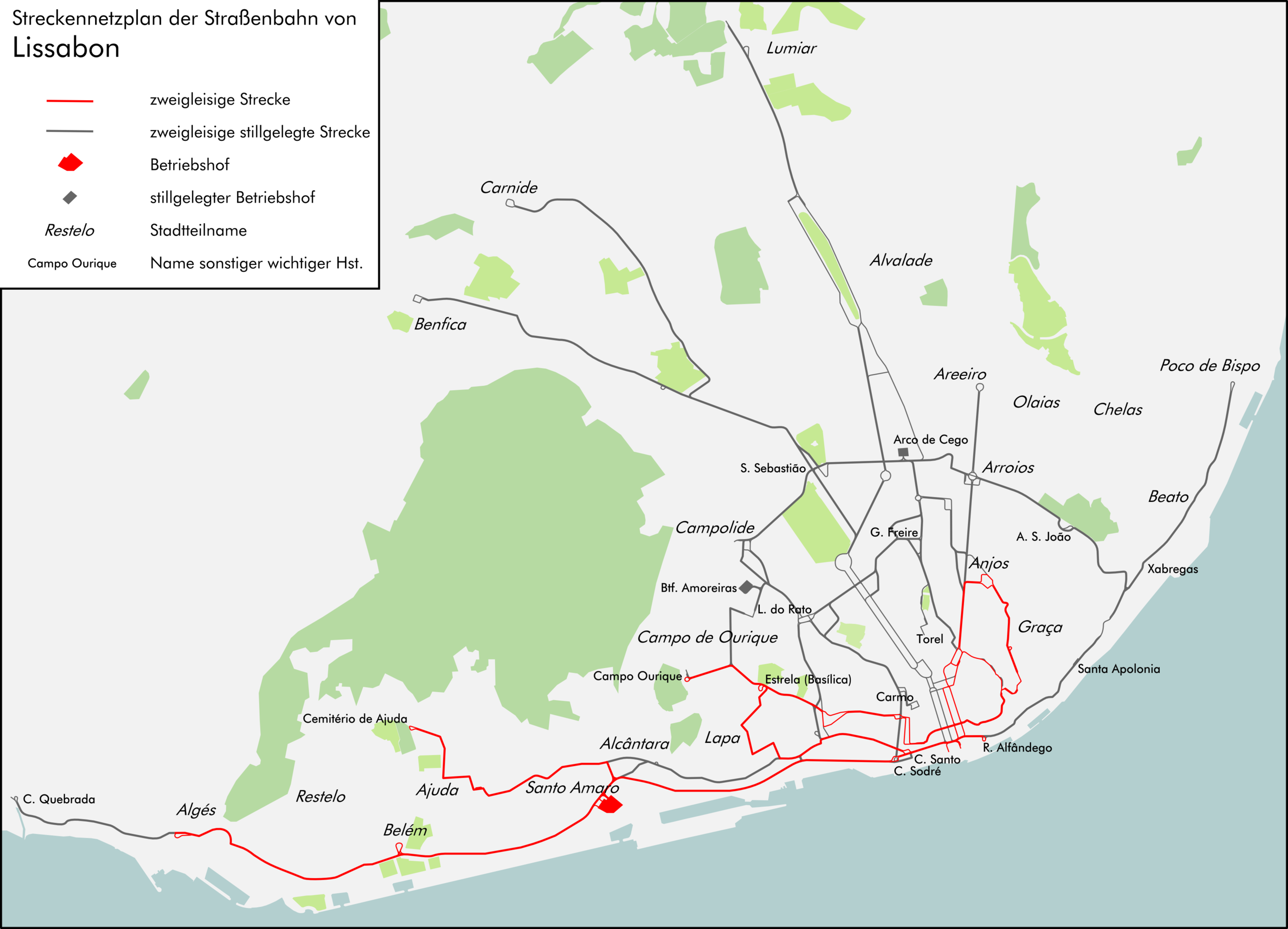
English: Map of tram-route sections in Lisbon.
Legend (in German): Zweigleisige Strecke = Double-track sections; Zweigleisige stillgelegte Strecke = Closed double-track sections (a thinner line indicates a single track); Betriebshof = Carhouse/depot; Stillgelegter Betriebshof = Closed carhouse/depot; Stadtteilname = Name of area/district; Name sonstiger wichtiger Hst. [Haltestelle] = Name of other important stop Deutsch: Streckennetzplan der Straßenbahn von Lissabon. |
|||
| Date | ||||
| Source | Own work, with data from Open Street Map | |||
| Author | Don-kun, Open Street Map | |||
| Other versions |
|

.svg)
Licensing
[edit]
I, the copyright holder of this work, hereby publish it under the following license:
This file is licensed under the Creative Commons Attribution-Share Alike 2.0 Generic license.
- You are free:
- to share – to copy, distribute and transmit the work
- to remix – to adapt the work
- Under the following conditions:
- attribution – You must give appropriate credit, provide a link to the license, and indicate if changes were made. You may do so in any reasonable manner, but not in any way that suggests the licensor endorses you or your use.
- share alike – If you remix, transform, or build upon the material, you must distribute your contributions under the same or compatible license as the original.
File history
Click on a date/time to view the file as it appeared at that time.
| Date/Time | Thumbnail | Dimensions | User | Comment | |
|---|---|---|---|---|---|
| current | 19:26, 2 February 2012 | | 3,494 × 2,521 (812 KB) | Don-kun (talk | contribs) | some corrections and more names |
| 18:33, 25 January 2012 |  | 3,494 × 2,521 (777 KB) | Don-kun (talk | contribs) | names | |
| 20:09, 14 January 2012 |  | 3,494 × 2,521 (757 KB) | Don-kun (talk | contribs) | names and depots | |
| 17:51, 7 January 2012 |  | 3,494 × 2,521 (689 KB) | Don-kun (talk | contribs) | names and corrections | |
| 16:32, 29 November 2011 |  | 3,494 × 2,521 (436 KB) | Don-kun (talk | contribs) | fixes and more tracks | |
| 19:44, 28 October 2011 |  | 3,500 × 2,526 (413 KB) | Don-kun (talk | contribs) | more tracks | |
| 19:53, 7 October 2011 |  | 3,433 × 2,691 (233 KB) | Don-kun (talk | contribs) | {{Information |Description ={{en|1=Map of Tram tracks in Lisbon.}} {{de|1=Streckennetzplan der Straßenbahn von Lissabon.}} |Source ={{own}}, with data from [http://www.openstreetmap.org/ Open Street Map] |Author =[[User:Don-kun|Don-kun |
You cannot overwrite this file.
File usage on Commons
There are no pages that use this file.
File usage on other wikis
The following other wikis use this file:
- Usage on de.wikipedia.org
- Usage on ja.wikipedia.org
- Usage on www.wikidata.org
- Usage on zh.wikipedia.org