File:Trail tree form.jpg
Jump to navigation
Jump to search

Size of this preview: 800 × 450 pixels. Other resolutions: 320 × 180 pixels | 640 × 360 pixels | 1,024 × 576 pixels | 1,280 × 720 pixels | 3,264 × 1,836 pixels.
Original file (3,264 × 1,836 pixels, file size: 3.43 MB, MIME type: image/jpeg)
Captions
Captions
Add a one-line explanation of what this file represents
Summary
[edit]
| Description |
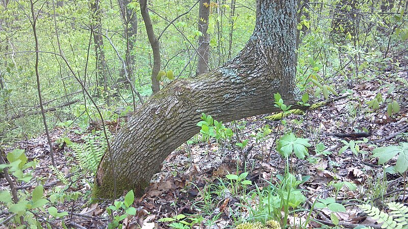
English: Image of "trail tree" form found in Zaleski State Forest, Ohio. This tree is about 15 inches diameter across the horizontal element, we did not carry a DBH tape with us at the time, the size is estimated. We date the damage to thirty to forty years before present. The tree is located along a minor ridge between drains at the break in slope. The ring scar is visible at high resolution but is partly obscured by spicebush leaves. |
| Date | |
| Source | Own work |
| Author | Knowandtell |
| Camera location | | View this and other nearby images on: OpenStreetMap |
|---|
Licensing
[edit]
I, the copyright holder of this work, hereby publish it under the following license:
This file is licensed under the Creative Commons Attribution-Share Alike 3.0 Unported license.
- You are free:
- to share – to copy, distribute and transmit the work
- to remix – to adapt the work
- Under the following conditions:
- attribution – You must give appropriate credit, provide a link to the license, and indicate if changes were made. You may do so in any reasonable manner, but not in any way that suggests the licensor endorses you or your use.
- share alike – If you remix, transform, or build upon the material, you must distribute your contributions under the same or compatible license as the original.
File history
Click on a date/time to view the file as it appeared at that time.
| Date/Time | Thumbnail | Dimensions | User | Comment | |
|---|---|---|---|---|---|
| current | 01:09, 27 November 2012 | | 3,264 × 1,836 (3.43 MB) | Knowandtell (talk | contribs) | User created page with UploadWizard |
You cannot overwrite this file.
File usage on Commons
There are no pages that use this file.