File:Toulouse line A map.svg
Jump to navigation
Jump to search

Size of this PNG preview of this SVG file: 800 × 199 pixels. Other resolutions: 320 × 79 pixels | 640 × 159 pixels | 1,024 × 254 pixels | 1,280 × 318 pixels | 2,560 × 635 pixels | 1,664 × 413 pixels.
Original file (SVG file, nominally 1,664 × 413 pixels, file size: 140 KB)
Captions
Captions
Add a one-line explanation of what this file represents
Summary
[edit]
| Description |
Deutsch: Plan der Linie A der U-Bahn von Toulouse
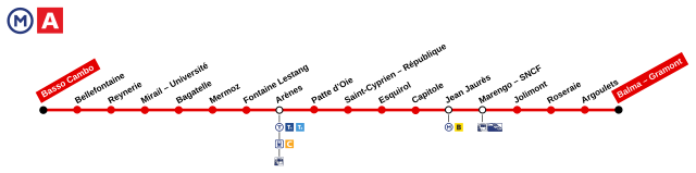
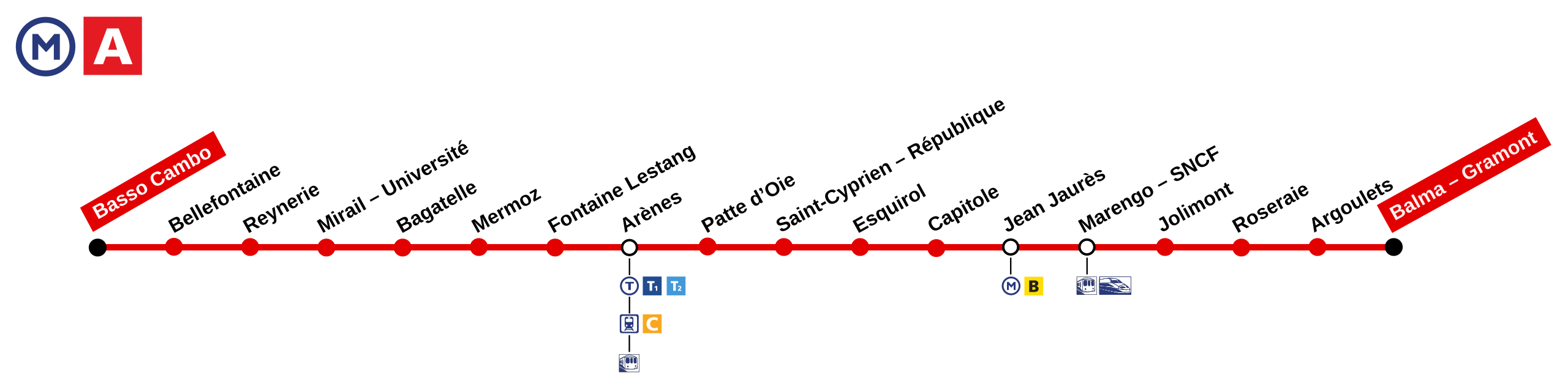
English: Map of Toulouse public transport line A (subway)
Français : Plan de la ligne A du métro de Toulouse |
| Date | |
| Source | Own work |
| Author | Sardon |
Licensing
[edit]
| I, the copyright holder of this work, release this work into the public domain. This applies worldwide. In some countries this may not be legally possible; if so: I grant anyone the right to use this work for any purpose, without any conditions, unless such conditions are required by law. |
File history
Click on a date/time to view the file as it appeared at that time.
| Date/Time | Thumbnail | Dimensions | User | Comment | |
|---|---|---|---|---|---|
| current | 13:46, 15 July 2021 | 1,664 × 413 (140 KB) | Dams W (talk | contribs) | Suppression des mentions aux lignes fictives D et F, n'existant que sur Wikipédia. | |
| 15:45, 27 July 2018 | 1,664 × 413 (213 KB) | Luna Lyons (talk | contribs) | Corrections mineures | ||
| 20:36, 28 October 2016 | 1,664 × 413 (161 KB) | Patroklis (talk | contribs) | Ajout de la correspondance T2 à la station Arènes et remplacement par les nouveaux logos. | ||
| 09:22, 28 August 2014 | 1,664 × 413 (89 KB) | Patroklis (talk | contribs) | Rectification de la correspondance avec le tramway T1 à la station Arènes. | ||
| 21:09, 28 June 2009 | 1,550 × 608 (86 KB) | PinkCityBoy (talk | contribs) | {{Information |Description={{en|1=Map of Toulouse public transport line A (subway)}} {{fr|1=Plan de la ligne A du métro de Toulouse}} |Source=travail personnel (own work) |Author=Sardon |Date=2009-01-14 |Permission= |other_versions= }} < |
You cannot overwrite this file.
File usage on Commons
The following 12 pages use this file:
- User:Chumwa/OgreBot/München/2016 October 21-31
- User:Chumwa/OgreBot/München/2018 July 21-31
- User:Chumwa/OgreBot/Potential transport maps/2016 October 21-31
- User:Chumwa/OgreBot/Potential transport maps/2018 July 21-31
- User:Chumwa/OgreBot/Public transport information/2016 October 21-31
- User:Chumwa/OgreBot/Public transport information/2018 July 21-31
- User:Chumwa/OgreBot/Public transport information/2021 July 11-20
- User:Chumwa/OgreBot/Transport Maps/2016 October 21-31
- User:Chumwa/OgreBot/Transport Maps/2018 July 21-31
- User:Chumwa/OgreBot/Transport Maps/2021 July 11-20
- User:Chumwa/OgreBot/Travel and communication maps/2016 October 21-31
- User:Chumwa/OgreBot/Travel and communication maps/2018 July 21-31
File usage on other wikis
The following other wikis use this file:
- Usage on fr.wikipedia.org
- Usage on fr.wikivoyage.org
- Usage on it.wikivoyage.org
- Usage on ja.wikivoyage.org